Increasing conductivity in Skeiðará glacier river (Grímsfjall volcano)

Since 20-January-2014 there has been increase in conductivity in Skeiðará glacier river that comes from Vatnajökull glacier. The reason for this change is that water is leaking from Grímsfjall volcano. Water levels have also been increasing and dropping during this time since this started.

gigjukvisl.svd.14.03.2014.vedur.is
The conductivity in Skeiðará glacier river from 20-January-2014. Picture from Icelandic Meteorological Office Facebook page. Copyright of this image belongs to Icelandic Meteorological Office.

Conductivity is now measured at 416 µS/cm and according to Icelandic Meteorological Office that is an high value coming from Grímsfjall volcano. This water also goes trough several lakes and before it reaches the sensor at Gígjukvísl bride. So at the source of Skeiðará glacier river this value is probably even higher. No major earthquake activity and no harmonic tremor activity has taken place following this water leak from Grímsvötnum glacier lakes. But it appears that some glacier quakes might be taking place at the moment. Such activity can be seen here on IMO website. Currently the volume of water in Grímsvötn glacier lakes is small since the eruption that took place in Grímsfjall volcano in the year 2011. Coverage of that eruption can be found here. At current time nothing more is expected to happen.

Donation notice: Please remember to support my work with donation. Otherwise I am going to have really bad month of March-2014 food wise. Thanks for the support.

Three earthquakes in Hekla volcano system

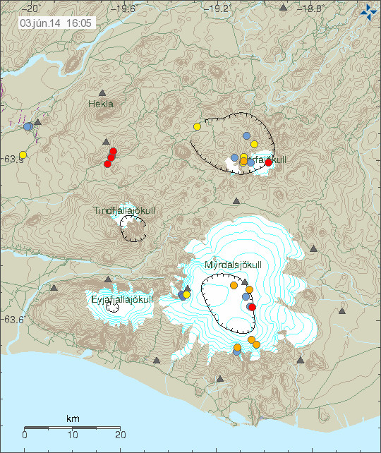
Today (03-Mars-2014) three earthquakes where detected in Hekla volcano system. All three earthquakes where small with none having magnitude above 1,0.

140303_1620
The earthquakes in Hekla volcano system. Copyright of this image belongs to Icelandic Meteorological Office.

No other change has been detected in Hekla volcano at this time. Earthquake activity has been taking place in Hekla volcano in the past. It is not clear what is the source or why this earthquake activity is taking place. It is possible to watch Hekla volcano here on my webicorders and live images can be found here. If something happens, but I think it is unlikely to do so at present time.

Donation notice: Please remember to support my work. Otherwise I am looking at really broke month of Mars-2014. It is also possible to buy my first e-book short story here. Thanks for the support.

Two magnitude 3,4 earthquakes in TFZ

Today (26-February-2014) at 08:06 and 08:12 UTC two earthquakes with the magnitude of 3,4 took place in TFZ. This earthquakes where felt in Ólafsfirði. This earthquake activity started on Monday and is continuing.

140226_1505
The two 3,4 magnitude earthquakes on TFZ. Copyright of this image belongs to Icelandic Meteorological Office.

mynnieyjafj2014
Historical and newest earthquake activity in this area of TFZ.Image is from here (Icelandic). Copyright of this image belongs to Icelandic Meteorological Office.

The earthquake activity in TFZ is ongoing. I am expecting more earthquakes in this area as is. When they might take place is impossible to know as of now. It is possible to monitor for earthquake activity in TFZ here (and here, Icelandic Meteorologist Office website). Any earthquake larger then magnitude 2,0 is going to appear on here. The larger the earthquake, more clearly it is going to appear on my webicorders.

Deep earthquake in Hamarinn volcano

Today (25-February-2014) at 09:49 UTC an deep earthquake took place in Hamarinn volcano (is under Bárðarbunga volcano at GVP database as Loki-Fögrufjöll). This earthquake had the depth of 29,6 km and magnitude of 1,8. This means it was created by magma movement rather then tectonic forces.

140225_2030
The earthquake that had the depth of 29,6 km is located 12,5 km south of Hamarinn (64,417 -17,605). Copyright of this image belongs to Icelandic Meteorological Office.

Hamarinn volcano last erupted in July 2011 [coverage of that can be found here] in an minor eruption that lasted for few hours but resulted in glacier flood in the area. Since then activity has dropped, but over the recent months it has been picking up again slowly. So far it is just earthquakes at depth. Harminn volcano is highly active volcano, even if it is not constantly erupting at the moment. The reason is that it is almost centre above the hot spot fuels the eruption activity in this area.

Blog post updated at 21:28 UTC.

Earthquake swarm on TFZ

Today (24-February-2014) at 06:49 UTC an earthquake swarm started on TFZ. Largest earthquake in this swarm had the magnitude of 3,0. No other earthquake has so far been larger.

140224_1720
The earthquake swarm in TFZ. It is aligned in north-south direction. Copyright of this image belongs to Icelandic Meteorological Office.

It is possible to monitor for earthquakes here with 5 minute delay. The activity appears most clearly on Böðvarshólar and Bjarghús geophone stations. This appears to be an continued activity from the earthquake swarm that started back in October 2012. I am expecting more earthquakes in the area since I don’t expect this activity to be over yet. Quiet times between earthquake activity should be expected. For some unknown reason that is how this area behaves and it is not known why that is.

Two minor earthquakes detected with my geophone network

It does not happen often. But I do detect earthquakes sometimes that Icelandic Meteorological Office does not detect on it’s network. The reason for that is simple. This earthquakes are too small to be detected by the SIL stations far away. My geophone network is able to detect earthquakes down to ML-2,0 when weather is good and if they are close enough. It doesn’t happen often, but it does happen. The earthquakes that I recorded on 20-February-2014 had the magnitude above ML0,0. What the magnitude is exactly I do not know. Since the software that I use does not allow for exact magnitude calculations (far as I know). The first earthquake took place at 12:36 UTC.

140220.123600.bghz.psn
The earlier earthquake that I detected at Bjarghús geophone station. This earthquake had the magnitude of 0,1 to 0,5. This image is released under Creative Commons Licence. See CC Licence page for more details.

140220.123600.bhrz.psn
The earlier earthquakes at Böðvarshólar geophone station. This earthquake had the magnitude of 0,1 to 0,5. This image is released under Creative Commons Licence. See CC Licence page for more details.

A second earthquake took place at 18:41 UTC. It was slightly larger than the first earthquake.

140220.184113.bghz.psn
The second earthquake at Bjarghús geophone station. This earthquake had the magnitude of 0,8 to 1,2 and distance of around 14 km. This image is released under Creative Commons Licence. See CC Licence page for more details.

140220.184100.bhrz.psn
The earthquake at Böðvarshólar geophone station. This earthquake had the magnitude of 0,8 to 1,2 and an distance around 17 km.This image is released under Creative Commons Licence. See CC Licence page for more details.

140220.184113.bghn.psn
All three channels of the second earthquake. This is Bjarghús geophone station. This image is released under Creative Commons Licence. See CC Licence page for more details.

140220.184100.bhrn.psn
All three channels of the second earthquake. This is Böðvarshólar geophone station. This image is released under Creative Commons Licence. See CC Licence page for more details.

I have not recorded any more earthquakes since this activity. Last earthquake before that took place in the year 2006 best to my knowledge. That was just one earthquake and Icelandic Meteorological Office was unable to locate that earthquake too due to lack of SIL stations in the area of my geophone. Back in 2006 I had one geophone and it was located in the village of Hvammstangi where I used to live. I don’t know if any more earthquakes are going to take place. It is difficult to know if any more earthquakes are going to take place. If they do they are going to appear on my geophones (Böðvarshólar and Bjarghús) in Húnaþing Vestra.

Minor earthquake swarm in Katla volcano

Over the past two days minor earthquakes have been taking place in Katla volcano. This is just minor earthquake activity. None of the earthquakes so far have reached the magnitude 1,0 that I know of.

140217_1150
Earthquake activity in Katla volcano. Copyright of this image belongs to Icelandic Meteorological Office.

What is interesting about this earthquake activity is that it is taking place inside the caldera of Katla volcano and it is taking place in high winter. When earthquake activity is normally low. What this means is unknown as is and I do not think an eruption is imminent in Katla volcano. This activity is however something to keep an eye on. Since Katla volcano is known to have erupted as early in May. Last such eruption took place in the year 1721 and lasted until October that same year (+-45 days). It is not known if eruptions can take place earlier, I am not going to rule it out even if it is not documented in historical documents about past eruptions in Katla volcano.

Donation notice: Please remember to support my work by donation. Otherwise I am going to be hungry for the rest of Feburary-2014 since I don’t have any money at the moment. I also have on sale my first short story. It can be bought DRM-free on Kobo.com here. It costs 4,99€ or $6,99 (plus your local VAT rate). Thanks for the support.

Minor earthquake swarm in Hengill volcano

Yesterday (16-February-2014) an minor earthquake swarm took place in Hengill volcano. This earthquake swarm took place because Orkuveit Reykjavíkur (OR) was pumping down water from hydrothermal processing in this part of Hengill volcano.

140217_1110
The earthquake swarm in Hengill volcano yesterday. Copyright of this image belongs to Icelandic Meteorological Office.

This type of earthquakes happen regularly when Orkuveita Reykjavíkur pumps water down into the ground at this location. At the moment this is just making minor earthquakes. This type of earthquake swarm only last during the period when water is being pumped down into the ground. Once that process is stopped the earthquake activity stops almost immediately.

Donation note: While I have started selling my first short story. I still need donations since I don’t have enough income from selling books at the moment to survive of it (it also takes 45 days to get paid from the day I reach the minimal payment of $100 [~73€ equal]). As for current month of February. I am going to thankful if I just make it since at the moment I am completely broke. I don’t even have 20€ on in the bank at the moment. I am thank broke now. Thanks for the support.

Around 1100 earthquakes recorded in Iceland during the month of January-2014

During the month of January-2014 around 1100 earthquakes where recorded according to Icelandic Meteorological Office. The largest earthquake during the month had the magnitude of 3,5 and took place on the Reykjanes peninsula. Earthquake swarm took place in Hveravellir geothermal area east of north Langjökull glacier.

skj2014jan
The total earthquake activity in Iceland during the month of January-2014. Copyright of this image belongs to Icelandic Meteorological Office.

Most of this earthquakes are small. Since no major earthquake activity took place in January-2014. There was however more activity in January-2014 then in December-2013 when only 800 earthquakes where detected by Icelandic Meteorological Office. More details about the earthquake activity in Iceland during the month of January-2014 can be found here, it is in Icelandic so Google Translate or such service is needed (quality of the translation is not guaranteed).

Donation note: Please remember to support me with donation if possible. My work so far depends on donations or people using my Amazon links (see Webstore) to support my work. Thanks for the support.

Quiet period in Iceland continues

The quiet period in Iceland continues as it has been doing for the past five months (according to my best knowledge). There is always some minor earthquake activity taking place, that is normal and should be expected. It is highly unusual if no earthquake activity was taking place for a long period of time.

140212_0955
All quiet in Iceland. Copyright of this image belongs to Icelandic Meteorological Office.

This has been a unusual period of quiet in Iceland best to my knowledge. At least in terms of earthquake swarms and such activity. Volcano eruptions in Iceland only happen on average every 4 to 5 years. Last eruptions (two minor ones) took place in the year 2011. When Grímsfjall volcano erupted. Same year there was also minor eruption in Katla volcano, a week later an minor eruption took place in Hamarinn volcano. since this activity took place it has remained quiet in Iceland volcano wise. There have been earthquake swarms in this period, several strong ones. AT the moment however there is not a lot of activity taking place. That might change at any time. But watching for activity takes a lot of patents since often nothing happens for a long time.

Donation note: According to my bank account. I am going to starve rest of this month. Since I got no money for anything left and all I do spend my money on is food after paying my bills. Donations are welcomed for this reason.

If people buy from Amazon there is also an other way to support me if you shop trough Amazon (I get that paid later on, so that is no help for me at the moment). The links to my Amazon store can be found here. I get paid 5 to 10% of the sale price of what people buy on Amazon this way. Thanks for the support.