Update on Grímsfjall volcano glacier flood

During the past several hours the amount of water in the glacier flood from Grímsfjall volcano has not dropped a lot, but this glacier flood started two days ago (27.01.2012 around 12:00 UTC). But that might be down to heavy rain in the area. Normally a glacier flood from Grímsvatn lake (inside the Grímsfjall volcano caldera) last for about one to two days during a normal glacier flood. It is believed that this glacier flood is from Grímsfjall volcano glacier lake. But it might be hard to confirm this during this time of the year.


Possible noise from the glacier flood on this SIL station. This might however be increased noise due to heavy rain on it. Copyright of this picture belongs to IMO.

I have known for some time now that Grímsfjall volcano is preparing for a new eruption. This I know because of the increase in earthquake activity and increased hydro thermal activity in Grímsfjall volcano. So far there is nothing that suggest that Grímsfjall volcano is going to erupt this time around, at least for the moment. I am expecting this glacier flood to be over in the next several hours. No earthquakes have happened in Grímsfjall volcano during this glacier flood. I do not expect them to take place unless magma starts moving inside Grímsfjall volcano. Be that dike intrusion or start of an eruption.

Icelandic news about the glacier flood.

Óbreytt ástand í Gígjukvísl (mbl.is)
Sama vatnshæð í Gígjukvísl (Rúv.is)
Vatnshæð hélst óbreytt í nótt (Vísir.is)

Glacier flood from Grímsvatn lake on Grímsfjall volcano

It has just been announced in the news that Grímsvant glacier lake has just had an glacier flood, but this lake is in the Grímsfjall volcano caldera. This glacier flood is believed to have started yesterday around 12:00 UTC. The glacier river that the water is running into is called Gígukvísl. So far this appears to be minor flood so far. But I do not know how much water as in Grímsvatn lake when this flood did take place.

At current time it is impossible to know if an eruption is going to take place following this glacier flood from Grímsvatn lake in Grímsfjall volcano.

I am going to post more information about this as I get them.

Icelandic news about this. Use Google Translate if you want to get incomprehensible news about this event.

Líklegt að Grímsvötn hafi hlaupið (Vísir.is)
Hlaup í Gígjukvísl (Rúv.is)
Jökulhlaup í Gígjukvísl (mbl.is)

Earthquake(s) in Hekla volcano

At 17:53 UTC there where two (or one) earthquake(s) in Hekla volcano. They where in the main volcano it self. The size of this earthquakes where ML06 and ML0.7, the depth was 2.5 km and 0.7 km. I am unsure what this means. But there is an slight possibly that an eruption might be under way. But at the moment no eruption has started so far. So only thing that can be done is to wait and see what happens next.


The earthquake in Hekla volcano at 17:53 UTC. Copyright of this picture belongs to Iceland Meteorological Office.

All that can be done for the moment is wait and see what happens. As so far this is the only earthquake in Hekla volcano. But that can change without warning at any time. I am going to monitor this as best I can this evening. But I am going to be away part of the evening and not close to any internet connection.

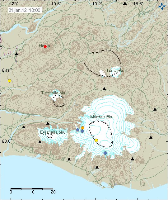
Update 1: An second earthquake did happen in Hekla volcano system during this morning. Its size was ML0.8 with the depth of 2.2 km. Other earthquakes that have happened also have been corrected. But the size of those earthquakes where ML1.0 at 0.1 km depth and ML0.7 at 8.3 km depth. Two of this earthquakes (ML0.8 and ML0.7) where not in Hekla volcano it self. But inside Hekla volcano system at good distance from the mountain it self.

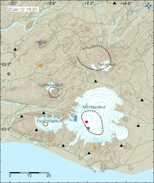
Hekla volcano system earthquake during the past 48 hours. Small earthquakes have been taking place in the south end of Hekla volcano system (north of Hvolsvöllur village) for several months now. What this means I have no idea. Copyright of this picture belongs to Iceland Meteorological Office.

Blog post updated at 18:41 UTC on 22.01.2012.

Small earthquake swarm in Hengill volcano

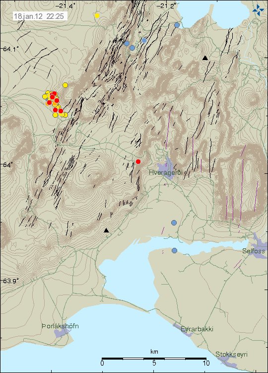
Yesterday (17.01.2012) an small earthquake swarm started in Hengill volcano. This earthquake is in the area where Orkuveita Reykjavíkur (OR) has been pumping down cold water from the hydro-thermal power plant that they have in the area. So far the largest earthquake in this minor earthquake swarm is just ML2.0 in size according to automatic size estimation. The depth of this earthquake swarm is around 5 km.


The earthquake activity in Hengill volcano today and yesterday (17.01.2012 and 18.01.2012). Copyright of this picture belongs to Iceland Meteorological Office.

The earthquake activity in this area repeats it self regularly due to water being pumped down into the ground. This has increased the risk of large (Mb5.0 or larger) earthquake in this area. But it is impossible to be sure if such events take place. As this is most likely just going to speed up an process that is already in place by nature forces in Hengill volcano (earthquakes, nothing else). So for the moment, the only thing that can be done is to wait and see what happens next.

Grímsfjall volcano prepares for new eruption

It is clear that Grímsfjall volcano is an restless volcano. In the year 2011 it had the largest eruption for at least 140 years. But even so that does not stop the volcano from preparing new eruption sometimes soon. But I am now expecting an new eruption from Grímsfjall volcano in the next 12 to 48 months or so at the earliest. The preparing for eruption clues have already started to show. But that is an slow increase in earthquakes in Grímsfjall volcano. Something that has always been a clear indicator of that an eruption might not be far off, even if nobody knows when and how big next eruption is going to be. It has been documented that Grímsfjall volcano does sometimes have an eruption every once or two year when the activity is at highest. But since the year 1983 the eruptions in Grímsfjall volcano have been getting more frequent and larger, the largest one so far being last year.


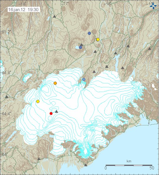
The latest earthquake in Grímsfjall volcano. It has not been reviewed so it’s location might change. Copyright of this picture belongs to Iceland Meteorological Office.


GPS data from the past 6 months (I think). As can be seen not a lot of magma has been going into Grímsfjall volcano system since the large eruption that started 21.05.2011. So far the inflation has only been around 100 mm to date, but even so that is more then whole inflation of Eyjafjallajökull volcano in the year 2010. But that was only around 60 mm for comparison. Copyright of this picture belongs to Iceland Meteorological Office.

It is unclear what happens next in Grímsfjall volcano. But for us how watch volcanoes. This is going to mean a lot of waiting time until next eruption in Grímsfjall volcano.

Earthquakes about 88 km south of Höfn í Hornarfirði

Earlier tonight an earthquake swarm started around 88 km south of a town of Höfn í Hornarfirði. This area last had an earthquake or earthquake swarm in Week 22 (no map exist of it, but the earthquakes are in the weekly overview list) in the year 2007. Then the largest earthquake was around ML3.0 in size.

So far the largest earthquake has been around ML2.3 in size, with the depth of 9.4 km. But the earthquakes that are detected around ML2.0 in size. But given the distance from the SIL network. This size is the lowest size that can be detected from what I can tell. This is because of the distance from the closest SIL station and how few SIL stations are in this area that are able to detect earthquakes this far out in the ocean. Earthquakes like this regularly happen all around Iceland. But most are not detected due to lack of SIL stations in the area. For that reason it is impossible to know for sure how many earthquakes actually have taken place there, as the SIL network is only recording the largest ones in this area.


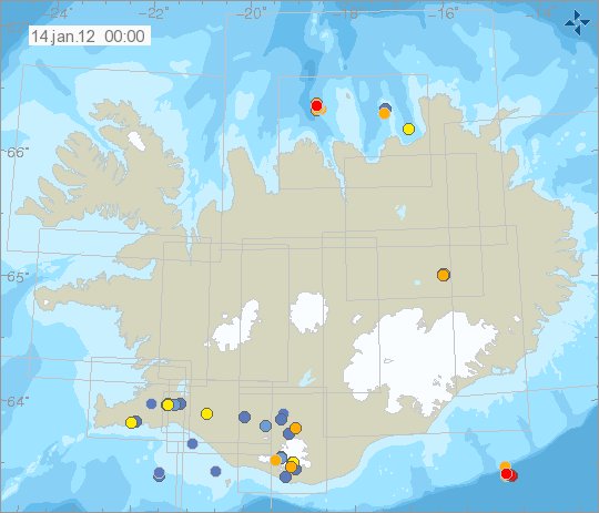
The area where this earthquake swarm is taking place is on the edge of Iceland volcanic shelf. This is often refereed to as intra-plate earthquakes. Copyright of this picture belongs to Iceland Meteorological Office.

This area is not volcanic last I knew. As it has no-known volcanoes today and most likely never has had any active volcanoes. In this area the Iceland plate is pushing down the oceanic crust that is on top of. This progress often creates earthquakes as we are now seeing. I have not yet found any research paper, as I am unsure what terms to use to look for the research.

Minor magma dike intrusion into Upptyppingar tuff mountain

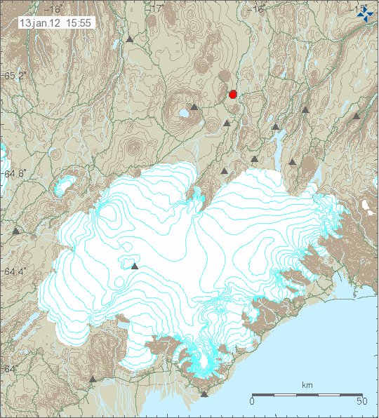
Yesterday (12.01.2012) there was an minor earthquake swarm in Upptyppingar tuff mountain. But they are inside Kverkfjöll volcano fissure swarm that extends several km away from the main volcano. The largest earthquake in this earthquake swarm was around ML2.0 in size, with the depth of 14.4 km. But this was also the deepest earthquake in this earthquake swarm. But most of the earthquakes had the depth of 14.4 km and up to 7.8 km. So I am sure that this was magma, rather then tectonic movements that did create this small earthquake swarm.


The earthquake activity in Upptyppingar tuff mountains. Copyright of this picture belongs to Icelandic Meteorological Office.

This might mean that there is more activity on the way in Upptyppingar tuff mountain. As this suggests that new magma has started to flow into the magma sill that has formed under the Upptyppingar tuff mountains. It is hard to know or if there is going to be an eruption there. But I find it most likely going to be the case. But it might well be good 10 to 20 years into the future until an eruption happens in that spot. But activity started in this area in the year 2007, so there already have been good 5 years since activity started in Upptyppingar tuff mountain. For the moment however, it is all wait and see and earthquakes.

Special donation help wanted!

I want to do something for my mom and dad. How are not the most technical people in the world. The fact is that where they live there is no mobile signal inside the house, but it is good out side the house. This can be fixed with an GSM repeater. But that costs money. Around 47.000 ISK, 2.189 DKK, 244 GBP, 294€, $372. I am going to get permission from the mobile companies and the authorities in Iceland to setup this minor repeater in the licensed spectrum (900Mhz). I want to do this. But I currently do not have the money to do this at present time. That is why I am asking for donation so I can do this. But I want to buy them the smallest GSM repeater that is possible to buy in Iceland, just so that they can get GSM signal inside the house.

Thanks for the support. 🙂

Minor earthquakes in Hekla volcano system

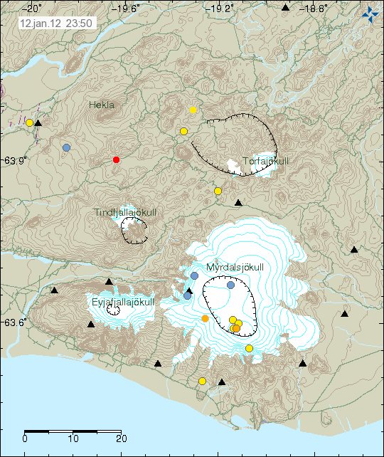
During the past 24 to 48 hours there has been some unusual and interesting earthquake activity in south part of Hekla volcano system. I am unsure on what this means, as normally Hekla volcano does not have any earthquakes before an eruption. However, that is not the only type Hekla volcano can and has erupted over the centuries. One of the aspect of Hekla volcano eruptions is that it can and has erupted in fissure eruptions outside the main mountain. This type of eruptions can last from few week and up to almost a year. Based on the limited historical records of such events. This type of events are always basaltic lava events that do not make a lot of volcano ash when they start.


The earthquakes in Hekla volcano during the last 48 hours. Copyright of this picture belongs to Iceland Meteorological Office.

There are clues that Hekla volcano might be about to have an fissure eruption some time in the future. But when and where is impossible to know for sure at current time. How that is going to manifest it self when the time comes is also impossible to know for sure. At current time there is however no eruption starting in Hekla volcano. When it might start is an good guess, with no answer to it.

New earthquake activity in Upptyppingar tuff mountains

During last week and on 5. January 2012 there where few earthquakes in the Upptyppingar tuff mountains. This mountains are not volcano by definition (yet anyway). But since the year 2007 there has been magma intrusion into that area. This magma intrusion however stopped and has been stopped for several years now. But that might be about to change. As on 5 January 2012 there where few small earthquakes with the depth of 12 km. Last eruption that took place in the Upptyppingar tuff mountain area where about 12.000 years ago, around the end of the last ice age. Considerable deformation has taken place in the crust in Upptyppingar tuff mountain since magma started to build up there. Current earthquake activity in Upptyppingar tuff mountain is not high at the moment however. But it has remained rather constant for the past 7 to 10 weeks at least. But due to lack of SIL stations in the area, it is hard to know how many earthquakes have exactly been taking place there at the moment.

Upptyppingar tuff mountains are part of Kverkfjöll volcano system. This new magma into Upptyppingar tuff mountains suggests that Kverkfjöll volcano might be about to enter an new time of activity. But they have been dormant since the year 1968 at least. But Kverkfjöll volcano have also been seeing some earthquake activity on its own.

It is most likely is the case that we are going to see eruption taking place in Upptyppingar tuff mountain one day. But the wait for it might be long however.

A research papers into the activity in Upptyppingar tuff mountain.

Resarch #1 (pdf file)
Research #2 (pdf file)

A ML3.6 earthquake in Krísuvík volcano (automatic size)

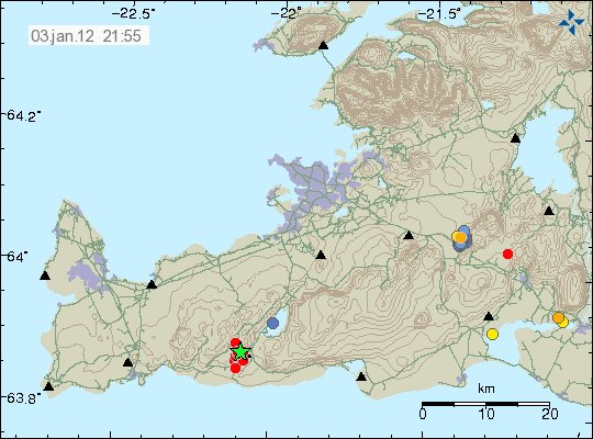
At 21:12 UTC on 3. January 2012 an earthquake with the automatic size of ML3.6 did happen in Krísuvík volcano. I do not yet know if this earthquake was felt in the nearby area. But I assuming that it has done so.

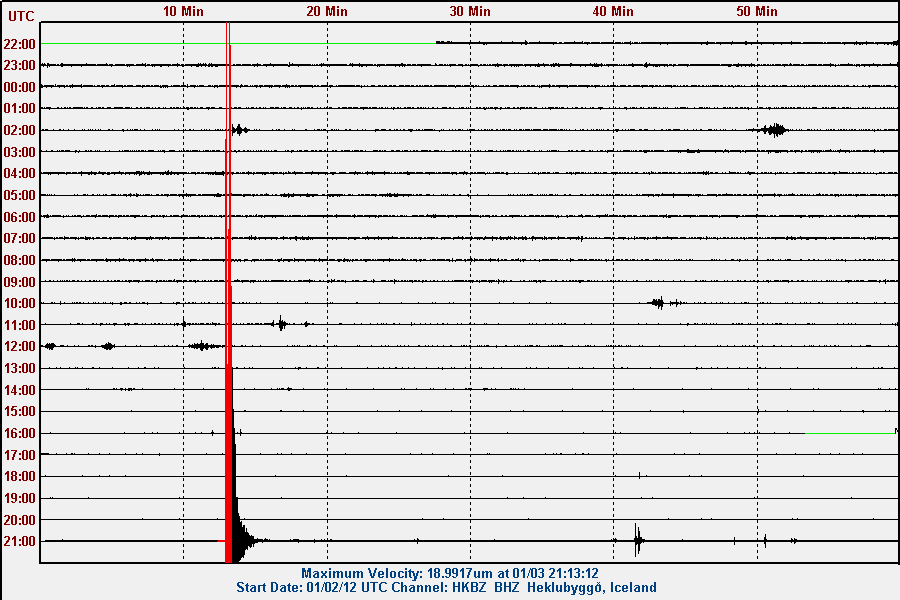
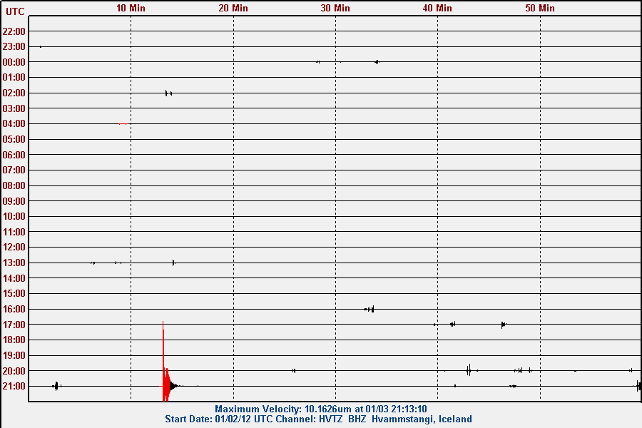
This earthquake did appear clearly on my geophones. Both in north and south Iceland. They can be viewed here. I am going to update this blog post as I know more. But this seems to be an start of earthquake swarm in Krísuvík volcano.

Update 1: It has been confirmed that this earthquake was felt in Reykjavík and nearby area. The automatic depth of this earthquake was 14.2 km according to Iceland Met Office.

Update 2: Earthquake swarm has started in Krísuvík volcano. The largest earthquake in this earthquake swarm after the main earthquake is ML1.1 in size. Larger earthquakes however might happen at any time in this earthquake swarm. But that is at least the experience so far.

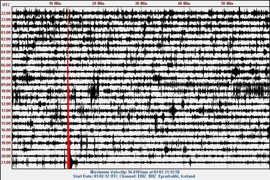
Update 3: Here are the traces of the earthquake. Sorry. But for the moment there are no high resolution pictures available as my main earthquake computer is offline until I move back to Denmark. See this blog post here for more details on that.


The location of the ML3.6 to ML3.7 earthquake in Krísuvík volcano. Copyright of this picture belongs to Iceland Met Office.


The ML3.6 earthquake as it did appear on Eyrarbakki geophone. This picture is released under Creative Commons Licence. Please see the CC Licence web page for more detail.


The ML3.6 earthquake as it did appear on the Heklubyggð geophone. This picture is released under Creative Commons Licence. Please see the CC Licence web page for more detail.


The ML3.6 earthquake as it did appear on the Hvammstangi geophone. This picture is released under Creative Commons Licence. Please see the CC Licence web page for more detail.

Blog post updated at 21:38 UTC.
Blog post updated at 21:45 UTC.
Blog post updated at 22:15 UTC.