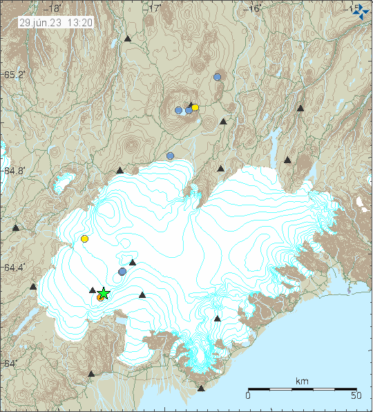
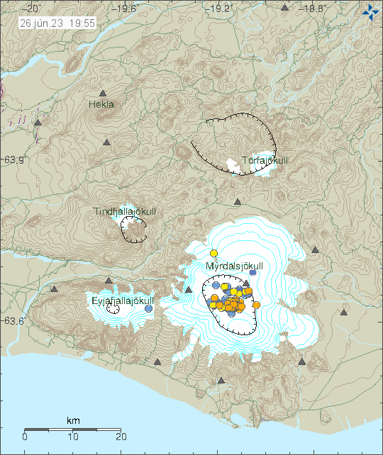
Earthquake swarm in Reykjanes volcano (out in the ocean)

During the night of 4. May 2023 an earthquake swarm took place in the Reykjanes volcano out in the ocean. This was not a large earthquake swarm. Largest earthquake recorded had a magnitude of Mw3,4. Other earthquakes where smaller in magnitude.

Green star and a cluster of earthquakes on down and west part of this image. Showing the Reykjanes peninsula. Few other earthquakes are dotted on the map in other volcanoes on the Reykjanes peninsula.
Earthquake swarm in Reykjanes volcano. Copyright of this image belongs to Icelandic Met Office.

This earthquake activity suggests an dyke intrusion in this area. This is part of Reykjanes volcano, but that volcano is in part out in the ocean. The Reykjanes volcano has been having regular dyke intrusion in recent years without it resulting in an eruption. That is most likely what is going to happen now.

Strong earthquake swarm in Katla volcano

This morning there was a strong earthquake swarm in Katla volcano. At the writing of this article the largest earthquake had a magnitude of Mw4,8 and the second largest earthquake had a magnitude of Mw4,7, the third largest earthquake had a magnitude of Mw4,5. This earthquakes where felt in nearby farms and towns close to Katla volcano. Currently, a lot of smaller earthquakes have happened in Katla volcano.

Red dots and green stars in Katla volcano caldera showing the main earthquake activity.
Earthquake activity in Katla volcano. Copyright of this image belongs to Icelandic Met Office.

There are no changes in harmonic tremor levels at the writing of this article. That makes an eruption unlikely to happen now. That might change later without warning. The air aviation code has been moved to yellow and can be viewed here.

I’ll write a new article if something more happens.

Earthquake swarm north of Grindavík town, next to Blue Lagoon

This morning (25. April 2023) an earthquake swarm started north of Grindavík town, next to the Blue Lagoon. 
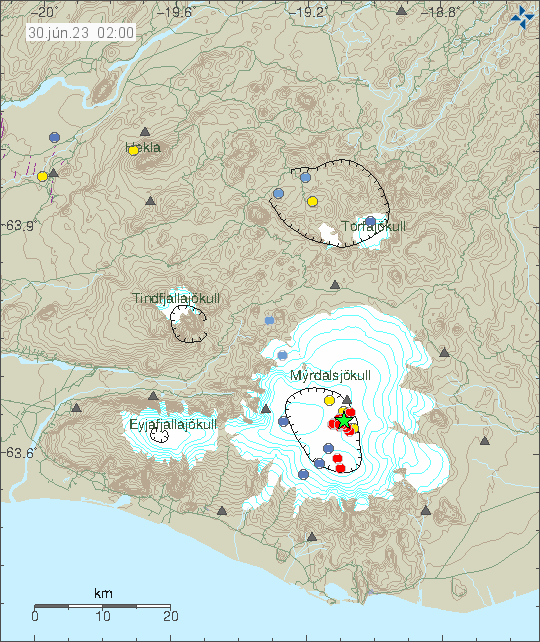
This earthquake swarm is ongoing at the writing of this article. If this is going to result in a eruption is impossible to know. The magma has reached the depth of 2 km and that is not good news if this continues to intensify. Large earthquakes do not need to happen before an eruption starts under the correct conditions in the curst and there has been a lot of dyke activity in Reykjanes volcano in last 3 years. Without that activity resulting in a eruption.

Red dots north of Grindavík town and next to the Blue lagoon on the map (the lagoon doesn't appear on the map). Time on map 25. Apr. 14:00.
Earthquake activity north of Grindavík town. Copyright of this image belongs to Icelandic Met Office.

Eruption at this location would be bad, because of the tourist infrastructure next to this location that is the Blue Lagoon. Only thing that can be done now is to monitor the situation and see if it changes from what is currently happening.

It is possible to view the earthquake swarm in high resolution on Skjálfta-Lísa and other private websites that have similar maps.

Earthquake swarm in Grímsfjall volcano

Today (23. April 2023) at 15:!5 UTC an earthquake swarm took place in Grímsfjall volcano. Largest earthquake in this swarm had a magnitude of Mw3,3. Few other smaller earthquakes also took place.

Green star and red dots under it in Grímsfjall volcano. Also in this image is the earlier earthquake in Bárðarbunga volcano, shown with a green star.
Earthquake activity in Grímsfjall volcano. Copyright of this image belongs to Icelandic Met Office.

There are no signs that Grímsfjall volcano is about erupt following this earthquake swarm. That might change without warning, but seems unlikely to happen at the moment. More earthquakes might happen in next few hours.

Earthquake in Bárðarbunga volcano

During the night of 23. April 2023 at 03:34 UTC an earthquake with the magnitude of Mw3,2 took place in Bárðarbunga volcano. This was just a single earthquake this time around. Depth of this earthquake was 4,6 km.

Green star in Bárðarbunga volcano. Showing the location of the newest earthquake in this volcano.
Green star in Bárðarbunga volcano. Copyright of this image belongs to Icelandic Met Office.

This earthquake shows that Bárðarbunga volcano continues to inflate. This is now normal earthquake activity and happens every one to three months, sometimes the time between earthquakes is longer.

Dangerous levels of Hydrogen sulfide nearby Múlakvísl glacier river (Mýrdalsjökull glacier / Katla volcano)

It has just been reported that (today 14. April 2023) that there is now a high levels of Hydrogen sulfide (H2S) close to Múlakvísl glacier river that comes from Mýrdalsjökull glacier, that is on top of Katla volcano. Tourists have been asked to be careful in the area. Currently the conductivity in Múlakvísl is not high, but according to Icelandic Met Office that is expected to change in next few hours.

Earthquake activity in Katla volcano at the moment is at normal background levels, that might change without warning if there is anything more happening with this sudden increase in gas levels. The gas levels changed early morning on 13. April 2023 according to Icelandic Met Office website.

Small earthquake swarm in south part of Brennisteinsfjöll volcano

Today (13. April 2023) there has been a small earthquake swarm in south part of Brennisteinfjöll volcano. This location had an earthquake swarm few weeks ago at this same location. It also was small in magnitude. Depth of this earthquake swarm has now decreased from 7 km to around 3 km. At least that is what it seems, based on the current earthquake data.

Red dots in south of Brennisteinsfjöll volcano showing the minor earthquake activity now taking place in this volcano. Nearby volcano also have minor earthquake activity, shown in orange to red dots.
Earthquake activity in Brennisteinsfjöll volcano. Copyright of this image belongs to Icelandic Met Office.

This earthquake activity shows a sign of magma movement. It is my opinion that the magma is now pushing it self trough the crust at this location. That can take a while, up to several weeks before an eruption starts. I did see something similar happen before the Bárðarbunga volcano eruption in 2014. That process took good three months before the eruption and was marked by small earthquake swarm like this one. How long this is going to take is impossible to know, because what type of crust is at this location is not well understood (outside of types of rock it is made out of at the first top layers). This is in my view an earthquake activity that needs to be monitored, because of possible eruption risk at this location. This is directly north of a small lake south of the earthquake swarm. If an eruption happens and the lava flows into the lake, that might create a lot of problems.

This earthquake swarm can be viewed here in more details. The website is Skjálfta-Lísa and is only in Icelandic.

Earthquake swarm in Fremrinámar volcano

An earthquake swarm in a volcano called Fremrinámar today (30. March 2023). This is the first time I’ve seen an earthquake swarm in this volcano. All earthquakes where small in magnitude and the magnitude range was from Mw0,1 to Mw1,0. Depth was 5,8 km to 9,1 km.

Fremrinámar volcano is located on this image south of Krafla volcano, located close to Mývatn lake in eastern north Iceland. Few orange dots are on the map showing the earthquake activity.
Fremrinámar is located south of Krafla volcano. Copyright of this image belongs to Icelandic Met Office.

This is the first time I’ve seen an earthquake activity in this volcano. I’ve been monitoring earthquake activity for close to 30 years at the writing of this article. Last eruption in Fremrinámar volcano took place around 3200 years ago (1200 BCE according to Global Volcanism Program). There is a second (and I assume newly discovered) volcano north of Fremrinámar volcano and south of Krafla volcano called Heiðarsporðar. That volcano last erupted around 2200 years ago. This earthquake activity doesn’t seems to be in that volcano, but this map on Icelandic Met Office website is not fully up to date it seems. Based on the volcano website Catalogue of Icelandic Volcanoes. This earthquake activity is only mentioned here now, because I’ve never seen an earthquake swarm in this volcano before.

Earthquake swarm in Brennisteinsfjöll volcano (Bláfjöll mountain)

Earlier this week, an swarm of earthquakes started in south of Brennisteinsfjöll volcano, also known as Bláfjöll mountain. This earthquake swarm started on a west to east fault north of a lake called Hlíðarvatn. This earthquake swarm has only been minor earthquakes, with magnitudes in the range of Mw0,0 and up to Mw2,3 but at the writing of this article, nothing above that magnitude. Over the week this earthquake swarm has evolved into a single area that seems to be circular, based on current earthquake activity. This strongly suggests that magma is the reason why this earthquake swarm is happening.

Red dots in south of Brennisteinsfjöll volcano. Showing the earthquake activity in that volcano. Red dots are also visible in Hengill volcano in a unrelated earthquake swarm.
Earthquake activity in Breinnisteinsfjöll volcano. Copyright of this image belongs to Icelandic Met Office.
Dots in different sized showing the earthquake swarm in Brennisteinsfjöll volcano. This is a image from Skjálfta-lísa website from Icelandic Met Office.
Earthquake as they appear on Skjálfta Lísa website from Icelandic Met Office. Screenshot from Icelandic Met Office website Skjálfta Lísa.
Google Earth image of the area where this earthquake swarm is taking place. It shows the road, the Hlíðarvatn lake and other feature in the landscape. Including a old lava flow the west of the current earthquake swarm. The landscape also seems to show older craters at this location, but those are weathered down to almost nothing.
Google Earth image of the area where the earthquake swarm is taking place. Picture is from Google Earth.

At the writing of this article, the earthquake activity is too small to start an eruption. Since this area is cold and the crust is too hard for the magma to flow freely inside it. Current depth of the earthquakes is around 5 to 7 km at the writing of this article and has not changed a lot during the week. While the Skjálfta Lísa image does not show this, it is possible that the earthquake activity has started to spread more east, compared to earlier in the week when this activity started. This earthquake actiivty might stop, as often happens in the early stages of a new eruption cycle in a volcano.

Earthquake activity in Bárðarbunga volcano

Today (19. March 2023) at 14:59 UTC an earthquake with magnitude of Mw3,1 took place in Bárðarbunga volcano. This is normal earthquake activity and shows the inflation that is happening in Bárðarbunga volcano is ongoing after the end of the eruption in 2015.

Vatnajökull glacier, in north-west of it, close to the edge of the glacier there's a green star and a red dot were the Bárðarbunga volcano is and it shows the earthquake activity that happened today.
Earthquake activity in Bárðarbunga volcano. Copyright of this image belongs to Icelandic Met Office.

This type of earthquake activity happens once to twice a month with a earthquake close to magnitude five happening every three to four months. This earthquake activity is getting lower with time, it is likely that it is going to take few more years until it completely stops.