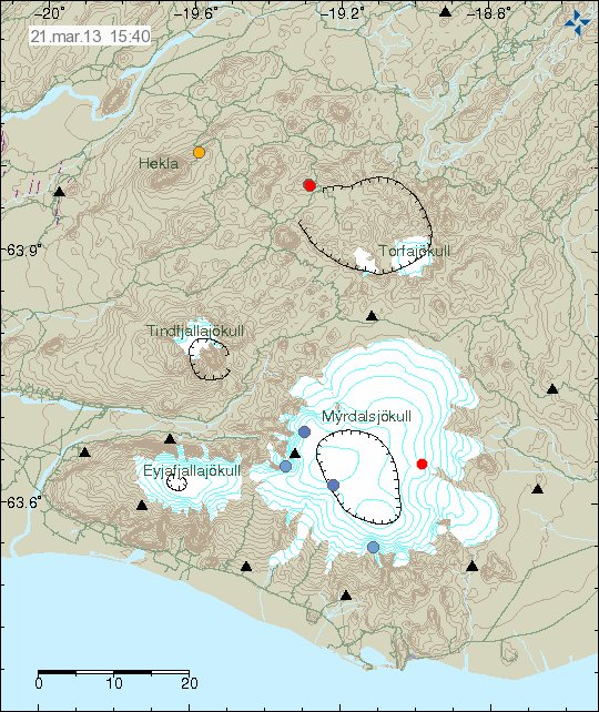
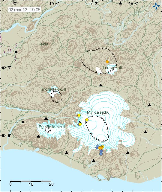
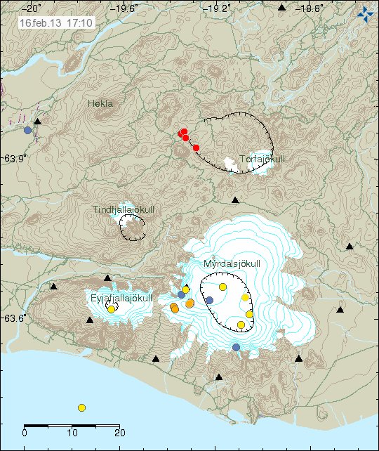
Earthquake swarm in Torfajökull volcano

Today (16.02.2013) at 15:11 UTC an earthquake swarm started in Torfajökull volcano. This is so far small earthquake swarm. With largest earthquake only having magnitude 2.6 (automatic result). Depth of this earthquake swarm is around 2 to 4 km. This earthquake swarm is taking place inside the volcano. So they might be magma related. But it is hard to know that for sure at the moment. This might just be normal tectonic earthquakes in this area. Earthquakes are common in this volcano. But major swarm activity does not seem to be for some reason.

130216_1710
Earthquake activity in Torfajökull volcano. The earthquakes are the red dots on this image. Copyright of this image belongs to Icelandic Meteorological Office.

It is hard to know exactly what happens next. But most often the earthquake activity in Torfajökull volcano stops after few hours. Last documented eruption in Torfajökull volcano took place in the year 1477 according to Global volcanism program (GVP). This earthquake activity appears clearly on my Heklubyggð geophone and Skeiðflöt geophone. The web site for my webicorders can be found here.

Interesting earthquakes close to Tungafellsjökull volcano

There is some interesting earthquake activity taking place close to Tungnafellsjökull volcano. This earthquake activity started last year in this area. It is unclear what is happening. But this might just be normal tectonic activity. The earthquakes are on the depth of around 4 km.


Earthquake activity close to Tungafellsjökull. Copyright of this image belongs to Icelandic Meteorological Office.

I am not sure if earthquake activity is going to continue in this area. As earthquake activity is intermittent in this area. The Torfajökull volcano however remains silent. But this activity is interesting. Since this area normally does not have earthquake, since it remains outside the main fault zones. But it is still inside the main rift zone in Iceland.

Magnitude 3.8 earthquake in Bárðarbunga volcano

During the night at 04:50 UTC there was an earthquake with the magnitude 3.8 in Bárðarbunga volcano. This appears to be a minor dike intrusions into Bárðarbunga volcano. This happens regularly in Bárðarbunga volcano. Often resulting in a lot larger earthquakes then current earthquake swarm that is taking place in Bárðarbunga volcano.


Earthquake activity in Bárðarbunga volcano. The star is the magnitude 3.8 earthquake. Copyright of this image belongs to Icelandic Meteorological Office.

It is impossible to know what is going on in Bárðarbunga volcano. But there is no risk for volcano eruption for now. Even if there is possibility of minor dike intrusion taking place in Bárðarbunga volcano at the moment. I am not expecting anything more at the moment. But more earthquakes can not be ruled out, as Bárðarbunga volcano is a earthquake active volcano.

Picture and video of Eyjafjallajökull volcano

Here is a picture of Eyjafjallajökull volcano that I took in December 2012. This is not a good picture. But that is mostly down to bad weather and strong wind at the time.


Click on the image for full size. This image is released under Creative Commons licence. Please see the CC Licence page for more details on this licence.

Here is a video that I took from this same area. It shows how bad the weather was.

Comparison of volcano eruptions

When there is nothing going on in Iceland. It is good to prepare for the future by checking out what has happened in the past. Here is a comparison of harmonic tremor data from few past eruptions. I only have limited set of data to work with here.

Grímsfjall volcano eruptions 2004 and 2011

Harmonic tremor indicates how strong the eruption is when it is happening. This is clearly visible on the harmonic tremor plots from the Grímsfjall volcano eruptions in the year 2004 and compared to the eruption in Grímsfjall volcano eruption in the year 2011.


Harmonic tremor in Grímsfjall volcano eruption in the year 2004. Copyright of this image belongs to Icelandic Meteorological Office.

This harmonic tremor plot is from the early start of the eruption. It clearly shows when the eruption starts and how it progressed during it’s first few hours.


Here is the volcano eruption start in Grímsfjall volcano on 23. May 2011. This is the start of the eruption. It clearly shows the difference from the eruption that took place in the year 2004. Both is that starts sharper. But is also a lot more powerful then the eruption in the year 2004. Copyright of this image belongs to Icelandic Meteorological Office.

Eyjafjallajökull volcano and Katla volcano

Sometimes it is useful to compare two eruptions of two different volcanoes. This is useful when you really don’t have anything else to compare with.


Harmonic tremor in Eyjafjallajökull volcano eruption back in the year 2010. This is from the second phase of the eruption. But I seems to have misplaced or not saved harmonic tremor data from the first phase of the eruption (at least I cannot find them for the moment). Copyright of this image belongs to Icelandic Meteorological Office.


Harmonic tremor connected to a minor eruption in Katla volcano in July 2011. This eruption was minor. But created a flood that took out a bridge. Copyright of this image belongs to Icelandic Meteorological Office.


Diffrent SIL stations from the same minor eruption in Katla volcano in July 2011. This clearly shows that this minor eruption in Katla volcano was possibly larger then eruption in Eyjafjallajökull volcano year earlier (2010). But it did not manage to break the ice of Mýrdalsjökull glacier. Copyright of this image belongs to Icelandic Meteorological Office.

Past data show and are useful to learn what happens in a volcano. For this reason I now save important information on what is happening in a volcano. So I can compare it with future activity when it takes place.

Magnitude 3.3 earthquake in Bárðarbunga volcano during the night

At 02:55 UTC today (18.12.2012) there was a magnitude 3.3 earthquake in Bárðarbunga volcano system. Earthquakes are common in this area so this activity is no surprise. Origins of this earthquakes are due to tectonic movements in the area. Not magma related changes.


Green star marks the magnitude 3.3 earthquake in Bárðarbunga volcano system. Copyright of this image belongs to Icelandic Meteorological Office.

Aftershocks have followed this earthquake. So far the largest one got the magnitude 2.2. More earthquake activity can be expected in this area. But that is normal and not unexpected.

Earthquake swarm in Katla volcano caldera

Yesterday (14.12.2012) from 20:50 UTC until 22:52 UTC there was an minor earthquake swarm in Katla volcano caldera. The largest earthquake in this swarm was a magnitude 2,2 earthquake. With the depth of 0,1 km. So it was a shallow earthquake. This is not uncommon for this part of Katla volcano. This earthquake activity has its origin in hydrothermal activity or changes in hydrothermal systems in this area of Katla volcano caldera.


Earthquake swarm in Katla volcano. This area has had earthquakes swarms before. Copyright of this image belongs to Icelandic Meteorological Office.

I do not expect anything special to result from this earthquake swarm. Since it is highly unlikely that Katla volcano is going to erupt in December. It is also a when it comes to earthquakes. Katla volcano has a lot of them during the year and earthquake swarm as this one should be expected to happen every once in a while.

Blog post updated at 10:42 UTC on 15.12.2012.

Earthquake swarm north of Kolbeinsey Island

During the night (on 15.12.2012) there was a swarm of earthquakes far north of Kolbeinsey Island. The distance from Kolbeinsey Island is about 100 to 200 km. What exactly is taking place at this location is impossible to know for now. Since this is far from Iceland and the SIL network. Last eruption is believed to have taken place around this area back in the year 1999, or at least there was an large dike intrusion at that time. What did happen exactly is not known.


The earthquake activity north of Kolbeinsey Island at midnight (00:00 UTC) 15.12.2012. Copyright of this image belongs to Icelandic Meteorological Office.


Earthquake activity at 09:00 UTC this morning (15.12.2012). More earthquakes have taken place since midnight. Copyright of this image belongs to Icelandic Meteorological Office.

There is a chance of more earthquakes in this area. It can also be expected that not all earthquake activity in this area is being detected by the SIL network. Due to distance, weather and ocean activity.

Dike intrusion in Askja volcano

Today (14.12.2012) around 12:00 UTC Askja volcano had dike intrusion. This dike intrusion was not in the main volcano it self. But a good distance away from it. But this is in a area that has erupted before in distant past in a fissure style eruption (just lava, no volcano ash). What is the case now I am not sure at the moment. But this dike intrusion was at the depth of 25 to 22 km. So it has long way to go before any eruption takes place. This dike intrusion did also not show any sign of moving upwards according to Rúv News of this event.


Earthquake map from IMO showing the dike intrusion clearly. Copyright of this image belongs to Icelandic Meteorological Office.

What this means in the long term is impossible to know at this point. But this is one event in a long series of events that started in March 2010. This is going to end with a eruption. Large or small is impossible to know until it happens. What is also impossible to know is when and where such eruption might take place. As is always the case with active volcanoes. There is at least no reason to panic about this. Not now, not ever.

Donations: I am still needing donations to cover my cost of buying 3G hardware for upcoming geophone stations Böðvarshólar (total cost around 1300 DKK, or 29900 ISK). I have got some donations already. But they just cover the cost of UPS and USB card for Skeiðflöt geophone station. But I was fixing technical problems with it. Thanks for the support.

Icelandic News about this

Á annan tug skjálfta austur af Öskju (Rúv.is)

Blog post updated at 23:29 UTC on 14.12.2012

Interesting earthquake swarm in TFZ

Today (12.12.2012) there was a interesting earthquake swarm in south part of TFZ (close to a place called Ásbyrgi). This earthquake swarm did consist mostly of minor earthquakes. With magnitudes of from ML0.2 and up to magnitude ML2.6. This earthquake swarm is tectonic in nature. I do not believe it is volcanic in nature. But this earthquake swarm is inside Krafla volcano fissure swarm or TFZ-NVZ two volcanoes. I am not sure in this case here.


The earthquake swarm is in the corner of this image. Copyright of this image belongs to Icelandic Meteorological Office.

This earthquake swarm might not mean anything special as is. But earthquake activity in this area has been some for the past few years. But it has so far never resulted in any major events so far in this area.