The Hunga Tonga-Hunga Ha’apai explosion on 15-January-2022

This is a special article about the eruption and the explosion in Hunga Tonga-Hunga Ha’apai volcano, close to Tonga in the Pacific Ocean. I don’t know a lot about this volcano so I might get details wrong. This is also not a long article, because of lack of my knowledge. Because of copyright, I can’t use any images in this article.

At 04:00 UTC on 15-January-2022 an eruption started in >Hunga Tonga-Hunga Ha’apai volcano, that is 65 distance from Tonga islands (population around 100.000). In what seems to be a process that only took about 1 to 3 hours, the eruption exploded with largest eruption force in modern history. This is possibly largest eruption since 1912 (Alaska) in the world or even largest eruption since Krakatoa in 1883. According to articles, research into this volcano suggest that it has an explosive period eruption phase every 1000 years, the last one being around the year 1100. The length of this eruption seems to have been 3 to 5 hours in total and in last 24 hours there have been reports of a lot smaller eruptions happening. Each of them only lasting few hours at most.

When the explosion happened it created a tsunami that hit Tonga few moments later with waves up to 1,13 meters high and Fiji islands where it with waves that where around 80 cm high (reports). Around 13 hours later, the tsunami hit the west coast of the United States and Canada, Los Angeles area and other coastal areas. The sound wave that followed was heard clearly 2300 km away in New Zealand and in Alaska at distance of 9373 km, the explosion was also heard clearly in Fiji islands that are in 700 to 1000 km distance. The air pressure wave that happened during the explosion did go over the Earth two times, it was detected in Iceland at around 17:00 to 18:00 on 15-January-2022 and the second wave was detected on 16-January-2022 at around 05:00 to 06:00 in Iceland.

It is going to take years to understand the size and effects of this volcano explosion because how remote it is, since it is out in the ocean and next populated area is 65 km away and that’s the only monitoring of this volcano, since other options are not possible for monitoring of Hunga Tonga-Hunga Ha’apai volcano.

The effects of the explosion was largest in Tonga that is now cut off from the internet because of damage to undersea fibre cable that connects them to the internet. How long that repair work is going to take depends on a lot of things, but it can take weeks or months until fibre connection is restored. There was also a lot of tsunami damage in Tonga, how extensive it is I don’t know because of lack of reports.

This is all I have for now on this eruption. I don’t know if I’ll write another article about this event, since I only cover world events that are major events and this volcano explosion has been classified in my system as a major volcano event.

More detailed article with images of the volcano

Why the volcanic eruption in Tonga was so violent, and what to expect next (The Conversation)

Trace of the Mw8,2 earthquake in Alaska, United States

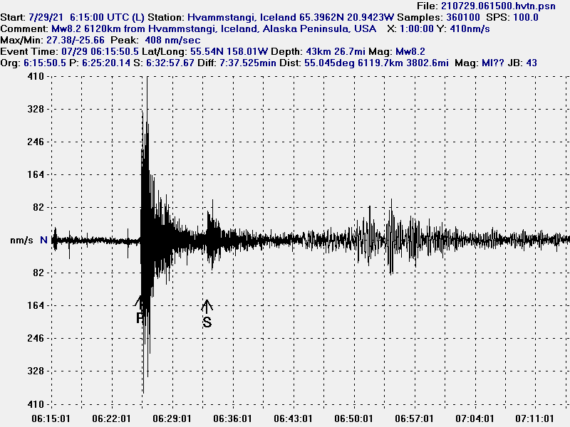
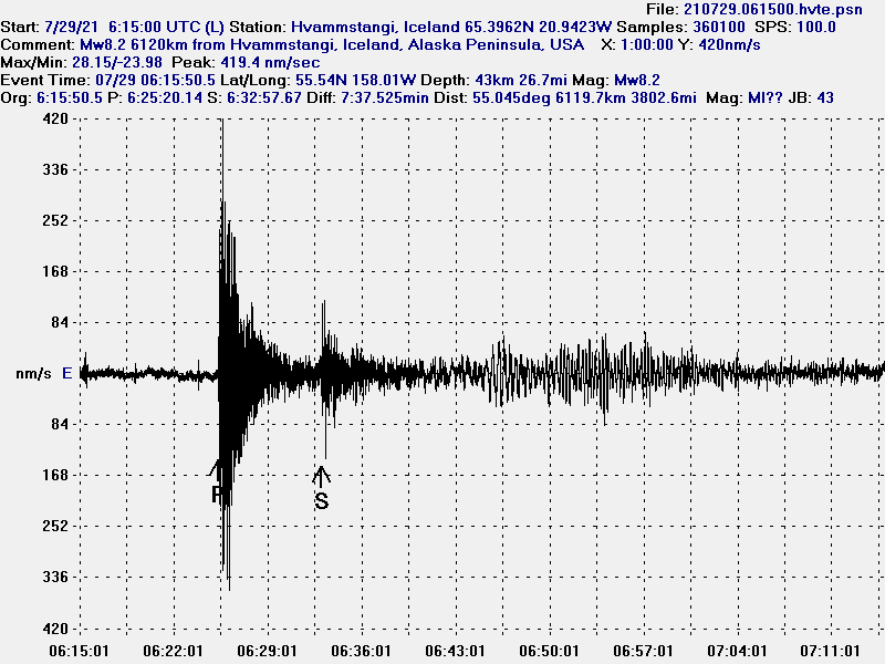
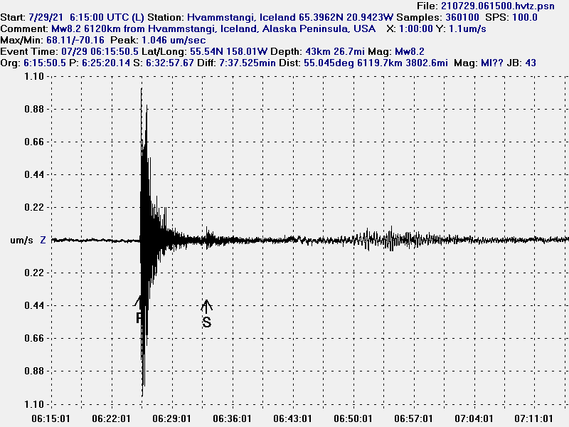
I don’t have anything to say about the earthquake that took place (on 29-July-2021 at 06:15 UTC) in Alaska, United States since I don’t know the area geology features. I am going to show the trace of this earthquake as it did appear on my geophone in Iceland.

The earthquake trace on north-south directed sensor that I have. It shows the P wave, the small S wave and the surface waves that I did record in Iceland.
The Mw8,2 earthquake as I did record it in Iceland.
Trace of the Mw8,2 earthquake in Alaska, shows the P wave that is strongest on the Z (vertical) line, along with the surface waves that I did record in a crude pattern
The Mw8,2 earthquake in Alaska, United States.
The Mw8,2 earthquake on a east-west direction. The P wave is the strongest followed by a small S wave and surface waves.
The Mw8,2 earthquake in Alaska, United States.

New Zealand – Kermadec island Mw7,4 earthquake detected in Iceland

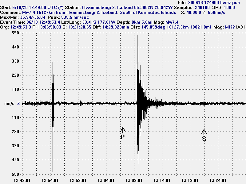
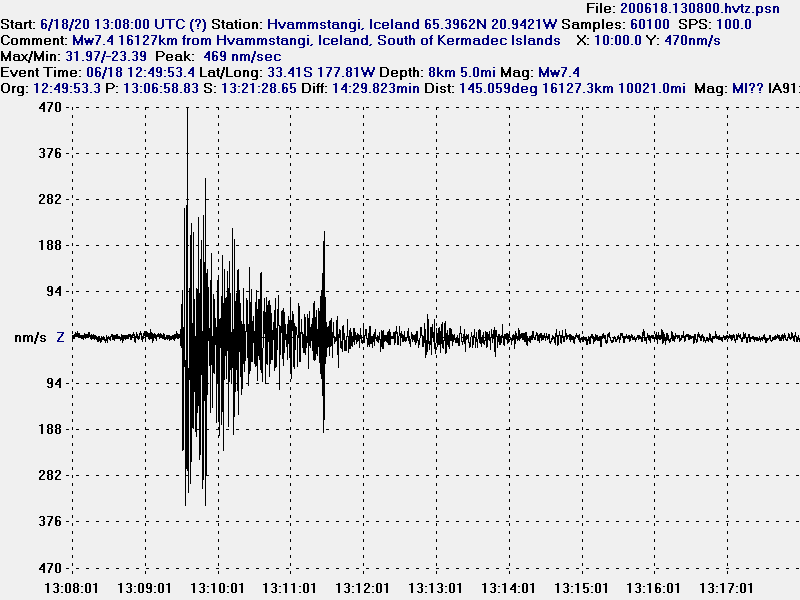
Today at 12:49 UTC an earthquake with a magnitude of Mw7,4 happened on the other side of the world. This earthquake was clearly detected in Iceland because the P-wave reflected off Earth iro-nickel core and that directed the P-wave towards Iceland where it was recorded as a Mw4,1 earthquake but was later downgraded to Mw1,5 at 92km depth (this is a fake local earthquake, SIL does not properly deal with this type of earthquakes).

Here is how this earthquake was detected with my geophones in Iceland.


Because of the reflection of the earthquake signal the P-wave arrives at a strange time compared to calculated time.


Short trace of the earthquake due to local noise that was creating problems for me.

I normally don’t record earthquakes from the other side of the world because I am using short period geophones to record earthquakes and those are only used normally for local earthquakes with distances less than 500 km. I can record earthquakes properly up to a distance of 6000 km if the earthquake is large enough (Mw6,0 or larger).

Donations

Please remember to support my work. Currently I am broke but things are starting to look better from July since I no longer have high hosting costs to pay. Thanks for the support. 🙂

Work

I am currently working from 08:00 to 16:00. This is going to lower my response time if anything happens in Iceland until after 16:00 when I get home from work.

Future plans

In the future I am going to be adding Google Adsense back to this website if I get approved. That is going to lower the requirement for donations once that system is in place at the cost of more advertising on this website. I don’t know when that is going to happen but this is going to take several months until I put this place into working phase because its tied into other plans that I have.

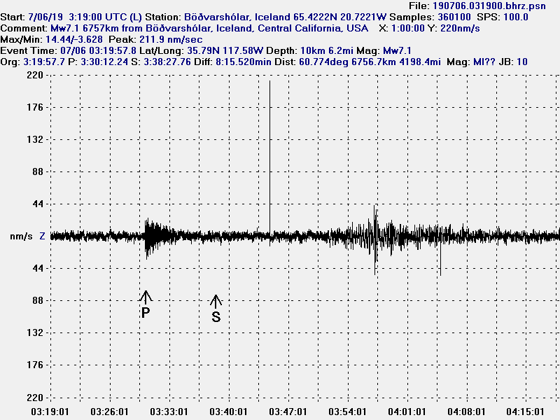
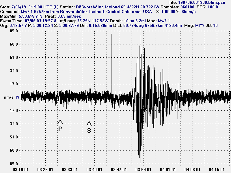
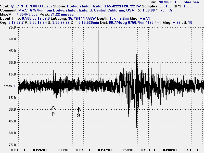
Recording of the California, United States, Mw7,1 earthquake

This is my geophone recording of the Mw7,1 earthquake in California. I don’t have any comments on this activity since I don’t know anything about the tectonic settings in California and how the set-up is regarding fault lines and tectonics in this area. I did only record the surface waves clearly and that is unusual given the distance from the source of the earthquake (6756 km).


The Z (vertical) recording.


The North-South recording.


The East-West recording.

The surface waves are strongest on North-South recording. I did not record the Mw6.5 earthquake on the 4th of July.

Update

Due to errors I discovered I have corrected this article and the images used.