Overview of the eruption in Geldingadalur in Fagradalsfjall mountain

This is a short overview of the eruption that is now ongoing in Geldingadalur in Fagradalsfjall mountain area. This is part of Krýsuvík-Trölladyngja volcano system according to latest information. This information might change as the time and more information is collected. This article is written on 20-March-2021 at 02:58 UTC.

  • This is the first eruption in Krýsuvík-Trölladyngja volcano system since the year 1340.
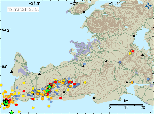
  • The eruption started at 20:45 UTC according to Icelandic Met Office.  The harmonic tremor from the eruption is almost invisible.
  • The fissure is at the writing of this article estimated about to be 1 km long with the direction south-west and north-east.
  • Currently the eruption is small and there is no risk of damage to any infrastructure. Next road (currently closed because of earthquake damage) that might get damaged is 2,5 km distance from the eruption site.
  • This eruption suggests that more eruption might start in different fissures once this eruption is over.
  • The valley that the lava is flowing into might get filled with lava if the eruption lasts long enough. The valley next to it is equally deep so there is no danger of this lava flow.
  • The eruption is in a area that is difficult to access even by a car.


The earthquake activity in the dyke between Fagradalsfjalls and Keili. Mostly just minor eartquakes show by red dots
The earthquake activity in the dyke. Copyright of this image belongs to Icelandic Met Office.

The eruption might only last for two to three days as it currently looks but that might change without warning since it is impossible to know for sure what is going to happen next with this eruption.

There are no good web cameras of this eruption since it is remote and started late on Friday night and the weather on Reykjanes peninsula is not good for today (20-March) or tomorrow (21-March).

Updated at 04:49 UTC. Web cameras added to this article.

Rúv – Beint vefstreymi af eldgosinu – Vogastapi
Beint vefstreymi frá eldstöðvunum – Rúv.is – New! This web camera is closest to the eruption.
Road camera 1
Live from Iceland – Keilir
Live from Iceland – Reykjanes

Article updated at 03:49 UTC. Information added. Spell check fixes.
Article updated at 04:52 UTC. Web cameras added.
Article updated at 14:44 UTC. New web camera added from Rúv.

Inflation slows in Krýsuvík-Trölladyngja volcano system

This is a short article that because the situation can change without warning and article is written on 19-March-2021 at 21:07 UTC. There have been updates to names used and now Krýsuvík-Trölladyngja name is used by Global Volcanism Program and Icelandic Met Office. Suggesting that the magma that is about to erupt has its origin in Krýsuvík volcano system eat of current centre of activity. This sometimes happens in Iceland when magma travels long distances deep underground.

Earthquake activity in Krýsuvík-Trölladyngja volcano system with two green stars showing two earthquakes with magnitude larger than three
Earthquake activity in Krýsuvík-Trölladyngja volcano system. Copyright of this image belongs to Icelandic Met Office.

Today at 15:01 an earthquake took place with magnitude of Mw3,1. This earthquake has in my view clear signs of magma movement close to the surface as the depth of this earthquake was just 0,1 km (100 meter).

A magnitude 3,1 earthquake that took place. Image shows P wave and a S wave and a long period after the S wave
A magnitude Mw3,1 earthquake that took place today at 15:01 UTC.

This earthquake strongly suggests that magma created it at shallow depth. It has not yet resulted in an eruption but it is a question if this the final sign before an eruption happens. The current quiet time might last up to 2 months but it is impossible to know for sure.

Deep earthquake activity in Trölladyngja (volcano)

Today (08-June-2017) there have been deep earthquakes in Trölladyngja (volcano). This earthquake swarm was shallower than last earthquake swarm that took place in Trölladyngja. Several months ago the earthquakes in Trölladyngja where happening at 28 km depth, but now they are at the depth range of 18,6 – 23,3 km, this means that the magma under Trölladyngja is migrating upwards at fast phase, a lot faster then I thought was possible. Earthquake swarm in November-2015 where slight off to the side, those earthquakes had the depth of 15 – 18 km as I wrote about here. Since November-2015 here has been other activity in Trölladyngja, but that has been in the form of one or two earthquakes so I have not written about it (I never bother with just one or two earthquakes at location due to the amount that happens daily in Iceland).


Earthquake activity in Trölladyngja (volcano), north-east of Bárðarbunga volcano fissure swarm. Copyright of this image belongs to Icelandic Met Office.

Last eruption in Trölladyngja was according to GVP (under Bárðarbunga volcano history) was 7000 years ago. Since then nothing has happened. There has been a lot more eruption in Dyngjuháls area and that area is also having deep earthquakes. That area is also covered with ~200 meters of glacier. It remains to be seen what happens next in the Bárðarbunga volcano saga.

Donations

Please remember to support my work. As it currently stands I’m completely broke and that’s no good at the start of the month. Thanks for the support. 🙂

Deep earthquakes close to Trölladyngja (Bárðarbunga volcano)

During the night of 15-November-2015 a swarm of deep earthquakes took place not far from Trölladyngja. The thing about Trölladyngja is directly connected to Bárðarbunga volcano and its eruption cycles. Trölladyngja it self was formed in a eruption in the year 5000 BCE, according to historical overview from Global Volcanism Program. According to some sources, Trölladyngja is a shield volcano, I don’t know if that is exactly correct. Regardless of what type of volcano Trölladyngja is, there is clearly something going on in it. Since this is not the first time I see earthquake swarm at this depth at this location. I doubt that this are stress related changes in the crust due the collapse of Bárðarbunga volcano caldera.

151115_0550
The earthquake activity in Trölladyngja (red dot). Image is from 05:50 UTC. Copyright of this image belongs to Iceland Met Office.

All of the earthquakes taking place were small, the largest had the magnitude of 1,1 and the depth was from 18 – 15 km.

In the early days of the earthquake swarm that started in Bárðarbunga in August-2014 a dyke intrusion pushed into this direction and than it just stopped as it lost the energy, or hit a obstacle that it was unable to break trough.

140817_1645
Image from August-2014. The earthquake activity close to Trölladyngja is clear on this image. Copyright of this image belongs to Iceland Met Office.

140818_1440
Image from August-2014. The earthquake activity close to Trölladyngja is clear on this image. Copyright of this image belongs to Iceland Met Office.

I don’t know yet what the chances are for an eruption at this location. More earthquake swarm activity is needed until the magma that is clearly down there breaks up. However the rifting that is taking place in this location might speed things up by unknown factor. This rifting might and possibly is allowing more magma entering this area deep underground without any earthquake activity. It is difficult to know what is going on at this location, so a lot of this is a speculation on what might happen. What actually happens in the end is a whole different thing and only time is going to tell us what happens next.