Earthquake in Kerlingafjöll volcano

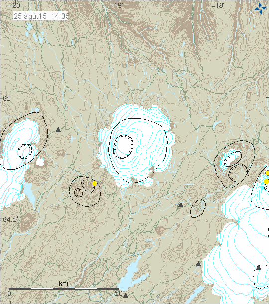
Kerlingafjöll volcano (no GVP profile) did have a earthquake today (25-August-2015). This was just one earthquake. Not of any special magnitude. Earthquakes are rare in Kerlingafjöll volcano and they don’t have any known historical eruptions. This one earthquake had the magnitude of 2,2 and depth of 11,1 km.

150825_1405
A rare earthquake in Kerlingafjöll volcano. Kerlingafjöll volcano are located south-west of Hofsjökull volcano. Copyright of this image belongs to Iceland Met Office.

Earthquakes appear to be extremely rare in Kerlingafjöll volcano. There were no earthquakes during the large earthquakes in 2000 and 2008 from SISZ due to stress changes that follows such large earthquakes. Since I started monitoring earthquakes in the current form this is the first earthquake I’ve seen in Kerlingafjöll volcano and that is over 9 year period. In that time, it is worth noting more SIL stations have been added, making the network more sensitive to smaller earthquakes around Hofsjökull volcano.

Missing person

Body of person unknown was found in Iceland on 17-August-2015. The remains where of a male that was 186cm, with blond/white shoulder long hair, in a hood that had “quicksilver” written on it. He was also wearing a shoe that had a star on the side. According to latest news the police now believe this might be a young French man that did come to Iceland in the summer of 2014, he did go to Höfn í Hornafirði in October-2014 (date unknown). He never left Iceland. This is being investigated by authorities in Iceland in cooperation with authorities in France. If you have any details or more information please contact the police in Iceland here. Latest Icelandic news about this can be found here in Icelandic.

Article updated at 22:36 UTC.

Herðubreiðartögl earthquake swarm update 6-May-2014

This is an update on the earthquake swarm in Herðubreiðartögl on 6-May-2014. This information might go outdated quickly if the activity in this earthquake swarm changes suddenly.

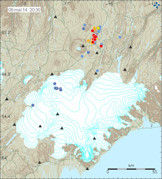
For the past 24 hours the earthquake activity in Herðubreiðartögl has been dropping. This means fewer earthquakes overall, the magnitude of earthquakes taking place has also been getting lower, with strongest earthquakes just in the magnitude 2,5 to 2,9 range. In the past 24 hours no magnitude 3,0 or larger earthquake has taken place.

140506_2030
The earthquake activity in Herðubreiðartögl on 6-May-2014. Copyright of this image belongs to Icelandic Meteorological Office.

140506_2030_tracer
The earthquake tracer at Icelandic Meteorological Office website clearly shows the drop in activity. Copyright of this image belongs to Icelandic Meteorological Office.

askja.counter.6-may-2014
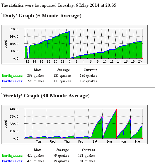
My earthquake counter clearly shows this drop in earthquake activity. It is for all of Iceland, but majority of earthquakes over the past days are from Herðubreiðartögl. This image is released under Creative Commons Licence. Please see CC Licence page for more details.

IASK.svd.06.05.2014.20.29.utc
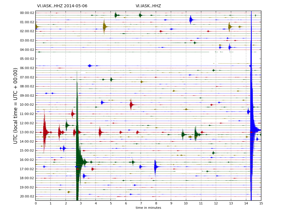
I did discover today that Icelandic Meteorological Office has updated its drumplot website. So its now possible to see the earthquakes directly. The drumplot here above is from Askja SIL station, it clearly shows the earthquake activity in Herðubreiðartögl. The website with the drumplots can be found here (I have just found this website in Icelandic, there does not appear to be English version available). Copyright of this image belongs to Icelandic Meteorological Office.

It remains difficult to know for sure what is the source of this earthquake swarm. There is a slight chance it might be due to magma injection at depth, but that remains unproven as is. My geophone stations (I only got two running now) are going to show the largest earthquakes and they are going appear clearly. It can be viewed here.

Donations: Please remember to support my work. Otherwise I am going to have a rather poor month of May. Thanks for the support!

Article updated at 21:22 UTC on 6-May-2014.
Article updated at 21:37 UTC on 6-May-2014.

The dormant volcanoes in Iceland

While all the active volcanoes in Iceland get all the press and coverage. There are volcanoes in Iceland that are not so active and have remain dormant for thousands of years now and currently do not show any signs of activity. Some have some hot spring activity. But that is about it for them. The following volcanoes in Iceland have not erupted in historical times. Some have not even erupted in past 12.000 years best to my knowledge. But as history has proved in other parts of the world. An dormant volcano can start to erupt when it feels like it and without any warning at all in some cases.

This is based on Global Volcanism Program data. So it might be subject to errors and updates.

Volcano

Hrómundartindur – Last eruption is unknown. This volcano is an stratovolcano.

Grensdalur – Last eruption was in Pleistocene and its current status is Pleistocene-Fumarolic. This volcano is an stratovolcano.

Grímsnes – Last eruption is believed to have taken place around 3500 BC. But this volcano is marked as tephrochronology. This volcano makes crater rows when it erupts.
Geysir – This volcano last erupted in Pleistocene and is marked as Pleistocene-Geysers. This is an stratovolcano.

Hveravellir – This volcano last erupted around the year 950 AD. It is currently marked as radiocarbon. This is an subglacial volcano.

Hofsjökull – This volcano has erupted sometimes in the last 12.000 years. It has the marking holocene. This is an subglacial volcano. The second volcano in this system is not marked in GVP database. But that volcano is named Kerlingarfjöll. I do not know when it last erupted. There is also an embeeded second volcano in Hofsjökull volcano that is Independent from the main Hofsjökull volcano (yes, this is the case it seems). I do not have any idea when that did last erupt.

Esjufjöll – This is an sub-glacier volcano in Vatnajökull glacier. Its last eruption is uncertain. But is believed to taken place in the year 1927. From the year 2000 this volcano has been showing signs of increased activity. This volcano is an stratovolcano.

Fremrinamur – This volcano is last believed to have erupted in the year 1200 BC. This volcano is an stratovolcano.

Þeystareykjabunga – This volcano last erupted around the year 900 BC. This volcano is an shield volcano.

Snæfellsjökull – This volcano last erupted around 200 AD. It is currently marked as radiocarbon. This is an stratovolcano.

Helgrindur (also known as Lysuhóll) – This volcano has no record of eruption. But it is thought that it erupted sometimes in the past 12.000 years. But exact time is not known. This volcano makes pyroclastic cones. This volcano is the smallest volcano system in Iceland.

Tindafjallajökull – It is unknown if this volcano has erupted during holocene. But the GVP information say that dozen of small eruptions took place in early holocene. This is an stratovolcano.

Snæfell – This volcano is located east of Vatnajökull glacier and south of Kverkfjöll volcano. It was once believed that this volcano was extinct. But new research into it has changed that opinion. This is most likely an stratovolcano. But I do not have it confirmed. This volcano has at least not erupted for several thousands years or more. Currently there are no information about this volcano in the Global Volcanism Program database.

Skrokkalda – This volcano is dormant. But I do not know if it has erupted in historical times or not, but I do no think that is the case. I am also not sure what type of volcano it is.

There are few more volcanoes missing due the fact that they are not in the Global Volcanism Program database. But I have them on a map that I own. So they are going to be added later when I update this blog post.