Earthquake activity in Oddnýjarhnjúkur-Langjökull volcano (Hveravellir)

Most of April there has been a earthquake swarm in the volcano of Oddnýjarhnjúkur-Langjökull (Hveravellir). This is in the north-east end of the volcano. At the writing of this article no earthquake has reached magnitude of Mw3,0.

Red dots east of Langjökull glacier showing the earthquake activity in Hveravellir area
Earthquake activity in Hveravellir area east of Langjökull glacier. Copyright of this image belongs to Icelandic Met Office.

This area seems to have earthquake activity every 5 to 10 years. With last earthquake activity in this area happening in November-2007. Some smaller earthquake activity happens between larger earthquake swarms. It is unclear what is going on there, but for now this just looks like tectonic activity. Because of lack of seismometers in this part of Iceland. Only the largest earthquakes are being shown on the earthquake map that Icelandic Met Office has. That is earthquakes with magnitude above Mw1,3. Earthquake swarm at more distance from Hveravellir can’t be ruled out. There are now around 12 year since last such earthquake swarm took place close to Blöndulón lake (a dam created lake in this area).

Donations

Please remember to support my work if you can. Thanks for the support. 🙂

Earthquake swarm close to Hveravellir (Langjökull north)

I don’t know a lot about this earthquake swarm close to Hveravellir (Langjökull north), due the lack of information. What I do know is that an earthquake swarm is taking place there and the largest earthquakes so far have the magnitude around 2,1. Largest reviewed earthquake had the magnitude of 2,1 at 2,1 km depth. Other than this information I don’t know for sure what is going on in this area.

160609_2035
The few earthquakes that Iceland Met Office has been able to locate with some certainty in Hveravellir. Copyright of this image belongs to Iceland Met Office.

ste.svd.09.06.2016.at.21.02.utc
This earthquake swarm is appearing clearly on nearby SIL station and only this one SIL station. Copyright of this image belongs to Iceland Met Office.

ste.svd.09.06.2016.at.21.02.utc
The drumplot of that SIL station also shows this earthquake swarm clearly. Copyright of this image belongs to Iceland Met Office.

I’m currently guessing that around 50 – 100 earthquakes have taken place so far, but without accurate data its difficult to know. The magnitude in this earthquake swarm is from 0,0 – ~2,1 so far. Larger earthquakes can’t be ruled out, but as the magnitude grows, so improves the SIL network ability to locate the earthquake magnitude and depth properly. For the smaller earthquakes, they are only going to appear on one to two SIL stations and that is not enough data to properly locate them or figure out exact magnitude.

I’m going to post updates to this earthquake swarm as it happens if needed.

Earthquake activity in Bárðarbunga, Öræfajökull, Langjökull north volcanos

This is going to be a little compressed article. Since I’m currently in Iceland. I’ll be back in Denmark on 18-May. No GVP links now. I don’t think that my laptop can handle it (its slowly turning into non-functional computer).

Bárðarbunga volcano

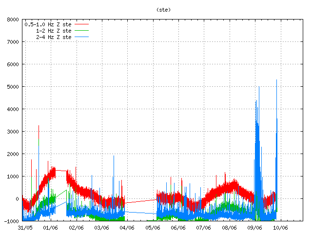
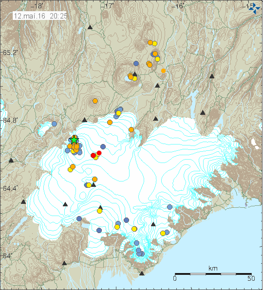
The regular earthquake activity in Bárðarbunga volcano continues, it follows the same pattern has it has been doing for the last 7 – 8 months.

160512_2025
The earthquake activity in Bárðarbunga volcano. Copyright of this image belongs to Iceland Met Office.

The largest earthquake had the magnitude of 3,2. Other earthquakes had smaller magnitude. This earthquake activity is like the earthquake activity before, there doesn’t seems to be a lot of difference between the earthquake swarms that are now taking place between weeks.

Öræfajökull volcano

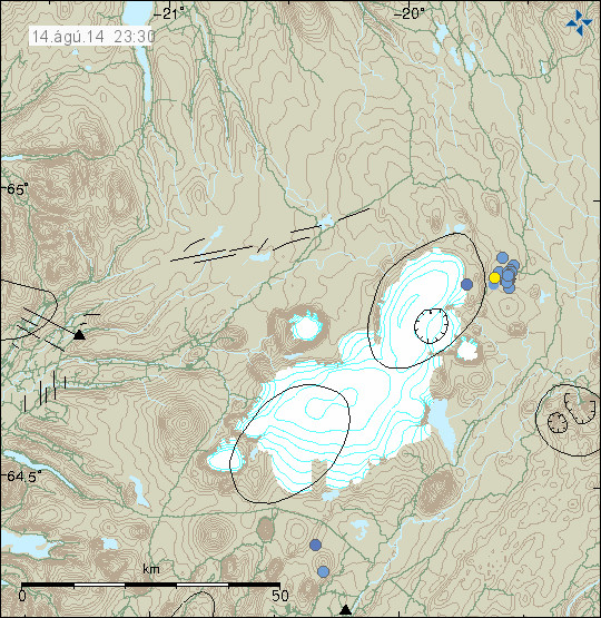
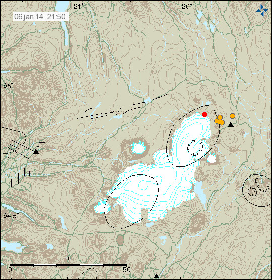
There is a interesting earthquake activity taking place in Öræfajökull volcano. It suggest that some magma is entering the volcano at depth (5 – 10 km). At the moment there is nothing that suggests an eruption is getting close, however the eruption history of Öræfajökull volcano is not well known and no reliable data exists on what might happen in the case of eruption. At the moment, all of the earthquakes taking place are minor, suggesting the amount of magma entering Öræfajökull volcano is minor at the moment.

Langjökull (north)

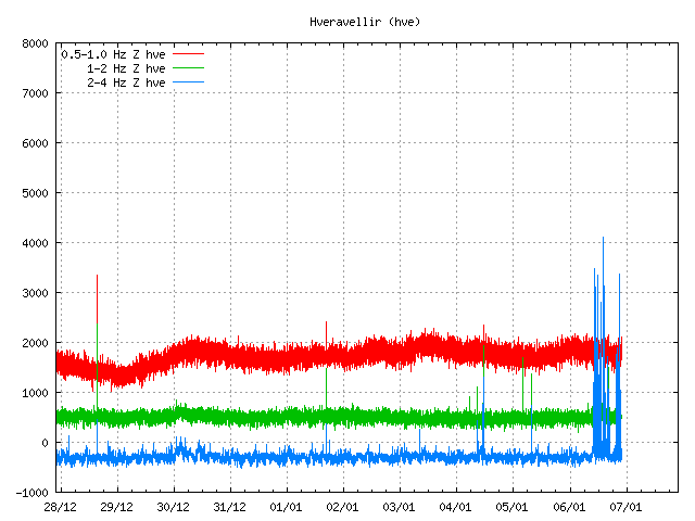
Today (12-May-2016) an small earthquake swarm took place in north Langjökull volcano. This earthquake activity has been taking place in this area since the year 2000, it was started by the magnitude 6,5 earthquake in SISZ. The reason for this earthquake swarm are unclear. No change in the main volcano has been observed, both in terms of earthquake activity or other changes. One idea is that this are stress changes in faults at this area, suggesting they might be lateral faults, not connected to the volcano it self.

160512_2110
The earthquake activity in Langjökull north volcano (Hveravellir). Copyright of this image belongs to Iceland Met Office.

None of the earthquakes that took place had strong magnitude, largest earthquake had the magnitude of 2,0.


New – Analyzing articles

I plan on to start writing analyzing articles about volcanoes in Iceland in order to attempt to explain what is going on with the most active one and what might happen. Those articles will take few days to write, that means I won’t write many of them each week if needed. This is also going to cover history of the volcano if that is possible. I am going to try and expand this website a little in order to bring in more readers.

Hardware support needed

Since I have to go the dentist when I go back to Denmark (sight). I can’t afford the hardware upgrade and maintaining my desktop computer (I got a failing hard drive). I also need hardware for setting up a second geophone computer in Denmark and a new Power supply for my main earthquake computer, it now running a 350W power-supply from a different computer, making it a little under powered.

Here is the list of hardware needed if anyone can help me with this.

1 500W power supply for my main earthquake computer (It has to be Intel six CPU pin power compatible).
1 1TB hard drive for my main desktop computer. The current hard drive is failing, its making clicking sounds, suggesting that its read head is about to fail.
1 1TB hard drive for my main earthquake computer. This for my main backup of all my data (earthquake data and other important data, images and so on). The second backup is on the internet. I so far haven’t been able to setup my third backup plan.
1 500GB to 1TB hard drive for my second geophone computer in Denmark.

Extra

1 Used laptop that is faster than 2,3Ghz and with more than 2GB ram. It can be used, it just has to work and be younger then 2010 model of laptop. It doesn’t have to have Windows installed on it. It does have to have a working hard drive.

Thanks for the support. 🙂

Earthquake swarm in Hveravellir

Two days ago (13-August-2014) an minor earthquake swarm took place in Hvervellir (volcano). Largest earthquake in this swarm had the magnitude of 2,5. All the earthquakes that happened had depth less then of 10 km.

140814_2330
Earthquake swarm in Hveravellir (blue dots). Copyright of this image belongs to Icelandic Meteorological Office.

Earthquake activity is fairly common in this area. It however works in a short activity periods with long quiet period between them. So far nothing suggest that major earthquake activity is going to take place there, as has happened in the past. If that happens, the largest earthquakes can go up to magnitude 5,0.

Earthquake swarm in Hveravellir

During the night of 6-January-2014 an earthquake swarm started in Langjökull volcano, the northern one. The nearby area is known as Hveravellir geothermal area. So far this has just been a minor earthquake swarm. With largest earthquakes not exceeding magnitude 2,0 at the moment.

140106_2150
The earthquake swarm in Hveravellir geothermal area. Copyright of this image belongs to Icelandic Meteorological Office.

The tremor plot of nearby SIL station shows that more earthquake activity is taking place then appears on Icelandic Meteorological Office website. This are then earthquake that are too small to be detected by other nearby SIL stations.

hve.svd.06-Januar-2014.22.01.utc
The earthquake activity at Hveravellir SIL station. Copyright of this image belongs to Icelandic Meteorological Office.

I do expect this earthquake activity to continue for some time now. It is impossible to know for sure if this activity is going to increase or not.

Earthquake swarm in Katla volcano, Kolbeinsey ridge, Hveravellir geothermal area

It has been a bit busy day earthquake wise in Iceland. But there has been more activity today then in past few weeks in Iceland. But it has been really quiet for a long time now in Iceland. But let’s start with the largest earthquake of the day.

Kolbeinsey Ridge

Today at 11:11 UTC there was an earthquake with the magnitude of ML3.65. This earthquake was not felt since it was more then 100 km away from nearest human population in Iceland. The earthquake took place on Kolbeinsey Ridge. It last erupted in the year 1755. No known eruption is known in this area since then. My geophone network did record this earthquake properly. The signal was strongest at my Hvammstangi geophone station. But it was also recorded on my Heklubyggð geophone station. On other geophone stations. The signal was too weak to be properly detected by my geophone.


The ML3.65 magnitude earthquake as it was recorded on my Hvammstangi geophone. This image is released under Creative Commons licence. Please see the CC Licence page for more details.


The ML3.65 magnitude earthquake as it was recorded on my Heklubyggð geophone. It is filtered at 1Hz. This image is released under Creative Commons licence. Please see the CC Licence page for more details.


The location of the earthquake. Copyright of this picture belongs to Iceland Meteorological Office.

Hveravellir geothermal area

There is an earthquake swarm ongoing (or it might be over. I have no good way to know that currently) at Hveravellir geothermal area. I only know there is an earthquake swarm there because of the tremor recording on Hveravellir geothermal area. But only two earthquakes have been large enough to appear on earthquake map on IMO web page.


The two earthquakes that did appear on IMO earthquake map. Copyright of this picture belongs to Iceland Meteorological Office.


However, Hveravellir SIL station did show that more was going on then did appear on the earthquake map. Most of this earthquakes are too small to appear automatic on the earthquake list. Some might even be too weak to be properly located by the SIL network. Copyright of this picture belongs to Iceland Meteorological Office.


Some of this activity did also appear on Skrokkalda SIL station I think. Copyright of this picture belongs to Iceland Meteorological Office.

Katla volcano

Katla volcano did have an new earthquake swarm during the night. This earthquake swarm had around 30 or so earthquakes. Most of them where located almost in the central caldrea. This type of swarm activity has now been ongoing since end of April, when it started rather sharply with an earthquake swarm. Since then it has had many earthquake swarm. But the current rate of earthquake swarm is around 1 to 3 earthquake swarm pr. Week. Normally they are in an new area inside the Katla volcano caldera.

My geophone station at Skeiðflöt records most of the earthquakes if the background noise is not too high during that time.


The earthquake activity in Katla volcano last night. Copyright of this picture belongs to Iceland Meteorological Office.

So far. This is just normal earthquake activity. It does not signal any chance of eruption activity so far. But this earthquake pattern is interesting. What it means is a different matter. So far, nobody knows for sure at this point in time. This activity seems to change hydrothermal activity inside Katla volcano caldera. This has also created minor glacier floods from Katla volcano caldera. But the flood have been seen on instruments that record water conditions in Múlakvíls glacier river. Glacier floods are marked by higher conductivity of the water, darker color and stronger sulfur smell (rotten egg smell). What happens next in Katla volcano is anyone guess. As Katla volcano has proven to be unpredictable volcano.

The dormant volcanoes in Iceland

While all the active volcanoes in Iceland get all the press and coverage. There are volcanoes in Iceland that are not so active and have remain dormant for thousands of years now and currently do not show any signs of activity. Some have some hot spring activity. But that is about it for them. The following volcanoes in Iceland have not erupted in historical times. Some have not even erupted in past 12.000 years best to my knowledge. But as history has proved in other parts of the world. An dormant volcano can start to erupt when it feels like it and without any warning at all in some cases.

This is based on Global Volcanism Program data. So it might be subject to errors and updates.

Volcano

Hrómundartindur – Last eruption is unknown. This volcano is an stratovolcano.

Grensdalur – Last eruption was in Pleistocene and its current status is Pleistocene-Fumarolic. This volcano is an stratovolcano.

Grímsnes – Last eruption is believed to have taken place around 3500 BC. But this volcano is marked as tephrochronology. This volcano makes crater rows when it erupts.
Geysir – This volcano last erupted in Pleistocene and is marked as Pleistocene-Geysers. This is an stratovolcano.

Hveravellir – This volcano last erupted around the year 950 AD. It is currently marked as radiocarbon. This is an subglacial volcano.

Hofsjökull – This volcano has erupted sometimes in the last 12.000 years. It has the marking holocene. This is an subglacial volcano. The second volcano in this system is not marked in GVP database. But that volcano is named Kerlingarfjöll. I do not know when it last erupted. There is also an embeeded second volcano in Hofsjökull volcano that is Independent from the main Hofsjökull volcano (yes, this is the case it seems). I do not have any idea when that did last erupt.

Esjufjöll – This is an sub-glacier volcano in Vatnajökull glacier. Its last eruption is uncertain. But is believed to taken place in the year 1927. From the year 2000 this volcano has been showing signs of increased activity. This volcano is an stratovolcano.

Fremrinamur – This volcano is last believed to have erupted in the year 1200 BC. This volcano is an stratovolcano.

Þeystareykjabunga – This volcano last erupted around the year 900 BC. This volcano is an shield volcano.

Snæfellsjökull – This volcano last erupted around 200 AD. It is currently marked as radiocarbon. This is an stratovolcano.

Helgrindur (also known as Lysuhóll) – This volcano has no record of eruption. But it is thought that it erupted sometimes in the past 12.000 years. But exact time is not known. This volcano makes pyroclastic cones. This volcano is the smallest volcano system in Iceland.

Tindafjallajökull – It is unknown if this volcano has erupted during holocene. But the GVP information say that dozen of small eruptions took place in early holocene. This is an stratovolcano.

Snæfell – This volcano is located east of Vatnajökull glacier and south of Kverkfjöll volcano. It was once believed that this volcano was extinct. But new research into it has changed that opinion. This is most likely an stratovolcano. But I do not have it confirmed. This volcano has at least not erupted for several thousands years or more. Currently there are no information about this volcano in the Global Volcanism Program database.

Skrokkalda – This volcano is dormant. But I do not know if it has erupted in historical times or not, but I do no think that is the case. I am also not sure what type of volcano it is.

There are few more volcanoes missing due the fact that they are not in the Global Volcanism Program database. But I have them on a map that I own. So they are going to be added later when I update this blog post.