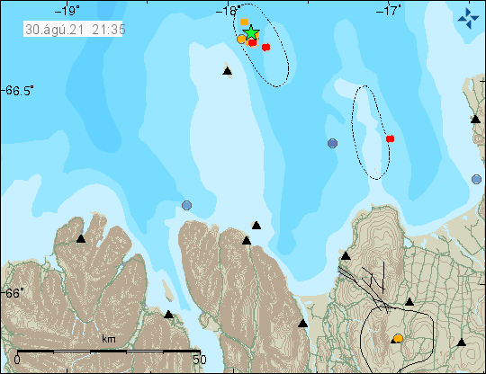
Yesterday (30-August-2021) an small earthquake swarm took place east of Grímsey island in Tjörnes Fracture Zone. Two largest earthquakes had a magnitude of Mw3,2.
Earthquakes east of Grímsey island. Copyright of this image belongs to Icelandic Met Office.
This earthquake swarm seems to have stopped for now. This area has frequent earthquake swarms and activity in this area of Tjörnes Fracture Zone might start again without warning.
This is a short update on the five month eruption day in the Fagradalsfjall mountain that is part of Krýsuvík-Trölladyngja volcano system.
The eruption continues its strange cycle of not erupting for few hours and erupting for few hours.
The consequence of this type of eruption is that the lava doesn’t flow that far from the crater. It just piles up next to the crater making the structure ever higher. I am currently estimating (this is a guess and might be wrong) the crater at 200 meters high (-+ 50 meters).
The eruption has now been going on for five months. Holuhraun eruption in Bárðarbunga volcano in 2014 to 2015 lasted for six months.
At the writing of this article there are no new craters open but it doesn’t rule out that new crater might have opened but are hidden under the amount of lava that is around the main crater. As there are some extreme large caves in this lava field. Allowing for a lot of space for new crater to form and start erupting unnoticed.
There are no more updates of the eruption at the writing of this article. That might change without warning but I don’t know if that is going to happen.
This is a short update on the eruption in Fagradalsfjall mountain that is part of Krýsuvík-Trölladyngja volcano system.
New crater has been confirmed in the eruption in Fagradalsfjall mountain. This crater started to form few days ago. It follows the activity in the largest crater and remains inactive during the time period when there is no activity in the large crater.
This new crater is going to change lava flows in the eruption and restart lava flows in the south-Meradalir and Geldingadalir.
Current the new crater is building up. It is on the larger crater rim and might be unstable and collapse are likely to happen.
Formation of new craters following the formation of this crater is likely. When and where new craters form is impossible to know in advance.
It is a question if this is a new phase of the eruption. I currently don’t have an answer.
The new crater is visible on all the web cameras.
Fog has been blocking the view of the eruption today and I expect that is going to be the case tomorrow (17-August-2021) and maybe next few days. This fog makes it difficult to see what is going in the eruption.
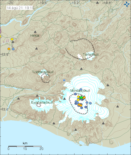
Today (14-August-2021) an earthquake with magnitude Mw3,1 took place in Katla volcano. Other earthquakes where smaller in magnitude.
Earthquake activity in Katla volcano. Copyright of this image belongs to Icelandic Met Office.
This earthquake activity appears to be normal late summer activity in Katla volcano. There was a minor increase in conductivity in nearby glacier rivers in last few days, that suggests that cauldrons have been emptying their water this summer. This is normal and happens almost every summer due to glacier melt.
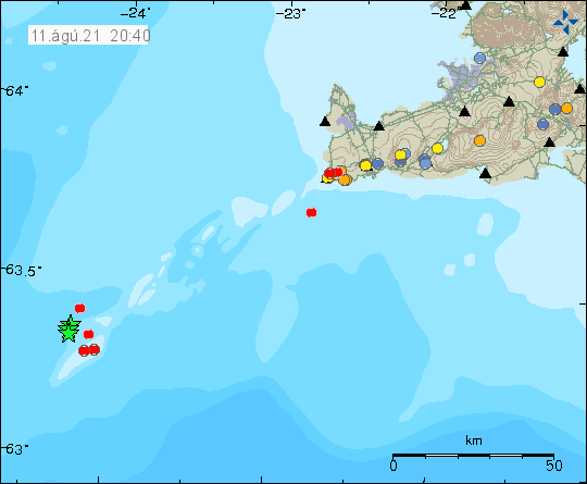
Yesterday (11-August-2021) there was a earthquake swarm on Reykjanes ridge. This earthquake swarm was not felt because of distance from the coastline.
Earthquake activity on Reykjanes ridge. Copyright of this image belongs to Icelandic Met Office.
Largest earthquake in this swarm had a magnitude of mb4,4 according to EMSC. Information about this earthquake can be found here. The distance from the SIL network made it difficult to know when this earthquake swarm started and stopped.
It is unclear if this part of the activity period that Reykjanes peninsula and Reykjanes ridge is now entering and is going to last for few centuries.
Donations
Please remember to support my work with donations. They help a lot more then the income from advertisement (as is the case everywhere). Thanks for the support. 🙂
This is a short update on what is going on the eruption in Fagradalsfjall mountain that is part of Krýsuvík-Trölladyngja volcano system.
The eruption continues as before with few hours of eruption and few hours of no activity. (This is my personal view of the situation) Each event is an active eruption as it would happen with any other volcano. The time between eruptions now is just shorter than in any volcano in Iceland. Its hours, not decades between eruption. I don’t know why this is happening like this.
Cracks have appeared in the viewing area hill closest to the erupting crater. Why this is happening is unclear. There are two explanations for this. The first one is that this are tension cracks because of the eruption and lava flows nearby to this hill . The second explanation is that this is deformation cracks because magma is about to start erupting in this part of the hill. Formation of new cracks was observed early on in the eruption in Fagradalsfjall mountain few days before an eruption started in that area.
There is now slightly less lava flowing from the crater. Current flow is up to 9m3/sec according to latest reports about the lava flow. This studies are done by Earth Science of University of Iceland and Icelandic Metrology Office.
This eruption remains small. Currently it is even smaller than Hekla volcano 2000 eruption that was the smallest eruption in Hekla in recorded history (according to the news). While the eruption remains this small the lava is not going to flow far or is going to do so slowly. Most of the lava is just going to build up next to the crater and next nearby area.
People continue to walk out in the lava and that is extremely dangerous. The lava field, where it is deep enough has large caves full of 1100C hot lava and if the roof breaks and people fall into it there is no saving anyone from this. Just break in the lava field crust allows for lava flows to break out with same deadly consequences.
This is possible mistaken reporting. There have been reporting of ash clouds or steam clouds off the coast during the evening of 7-August-2021. This would be in the volcano system Krýsuvík-Trölladyngja.
The ash cloud or steam cloud would indicate an activity off the coastline or possible eruption activity in the ocean. Explosive events like that appear a lot more clearly as harmonic tremor on SIL stations and according to news reports nothing has been seen so far in the harmonic tremor data. There have been no earthquake activity in the area where the clouds are supposed to have been seen.
The coast guard has been sent to this area, as they where nearby anyway. I don’t know if anything has been reported so far. The weather is fine in south Iceland and I don’t think there is a lot of ocean waves, but as this is the Atlantic ocean there can be ocean waves even if there is no wind, since the ocean waves can arrive from parts of the ocean with bad weather thousands of kilometres away.
If anything new is reported I am going to update this article or write a new one.
This is a short update on the eruption in Krýsuvík-Trölladyngja volcano system on 7-August-2021.
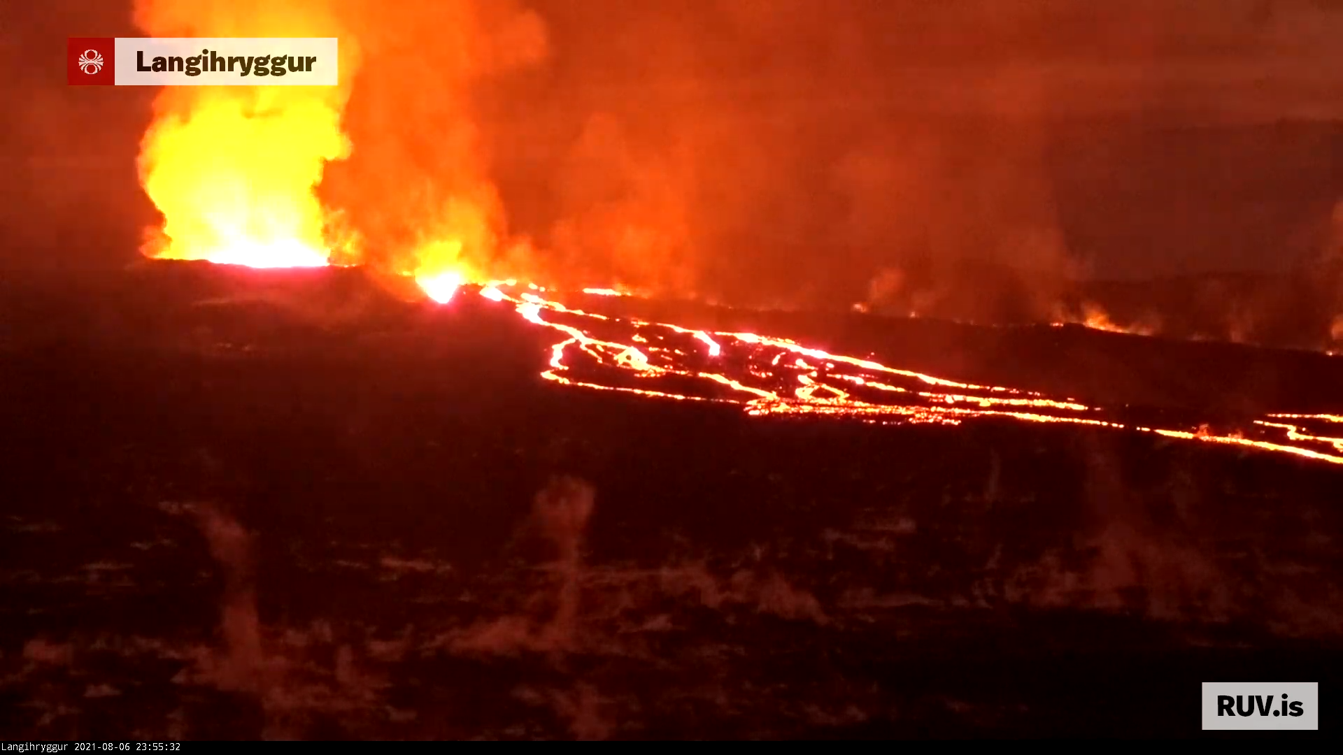
Over the last few weeks there has not been a lot to report about the eruption in Fagradalsfjall mountain. That changed tonight. The eruption seems to have entered a new stable phase. With constant eruption, rather than erupting every few hours and nothing happening for several hours after that. I don’t know if that is going to continue for long, but that is the situation at the writing of this article.
The eruption in Fagradalsfjall mountain. Copyright of this image belongs to Rúv ohf.
Most of the lava flow is going into Meradalir at the writing of this article. Some of the lava flow is happening underground and that lava flow is going into south-Meradalir that is just above Nátthagi valley. That can be seen as gas is now coming from that lava field and increase in gas emission shows that fresh lava is flowing under the crust of the lava. Surface lava paths can change without warning at any time.
Tourist continue to place them self in great danger by walking out in the lava field. If there is an accident there won’t be any recurse because it is going to be already too late anyway.
Update on 7-August-2021 at 13:48 UTC
Today (7-August-2021) at 08:00 UTC the eruption stopped. The harmonic tremor dropped quickly as the stop in the eruption was quick after going on for two and half day. Why this happens remains unclear. At the writing of this update at 13:49 UTC the eruption remains inactive.
Donation
Please remember to support my work with donations. Thanks for the support. 🙂
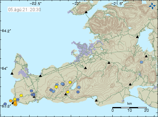
During the night and today on 5-Augustu-2021 an earthquake swarm took place in the Reykjanes volcano.
Earthquake activity in Reykjanes volcano. Copyright of this image belongs to Icelandic Met Office.
Largest earthquake in this swarm had a magnitude of Mw3,0 and other earthquakes at the writing of this article have been smaller. That can change without warning. Currently there is a possibly that this earthquake swarm is over.
Donation
Please remember to support my work with donations. It helps me keeping my self and this working going on. Thanks for the support. 🙂
During the night of 5-August-2021 an earthquake swarm took place in Tjörnes Fracture Zone (TFZ). At the writing of this article this earthquake swarm is ongoing.
Earthquake activity south-east of Grímsey island. Copyright of this image belongs to Icelandic Met Office.
Largest earthquake in this swarm had a magnitude of Mw3,0. Other earthquakes where smaller in magnitude. No earthquake has been felt in Grímsey island.
Donation
Please remember to support my work with donations. Since donations help me keeping this website and my self going. Thanks for the support. 🙂