Earthquake swarm in Herðurbreiðartögl

Yesterday (10-July-2020) an earthquake swarm took place in Herðurbreiðartögl mountains. There is no known volcano in this area and the source of this earthquake swarm is most likely an tectonic stresses in this area. The largest earthquake had a magnitude Mw3,2 (14:15 UTC) and Mw3,1 (17:47 UTC). This earthquake swarm is still ongoing but there aren’t many earthquakes happening at the writing of this article.


The earthquakes swarm in Herðubreiðartögl area. Copyright of this image belongs to Icelandic Met Office.

The mountains in this area where created in eruptions during last glacier period around 12.000 years ago or earlier.

Donations

Please remember to support my work with donations. It helps me to get by and work on this website. Thanks for the support. 🙂

Two earthquake swarms in Iceland today (02-June-2017)

Today (02-June-2017) there have been two earthquake swarms taking place in Iceland. Both are minor in terms of magnitude, the second earthquake swarm is now getting close to 60 – 80 earthquakes at the moment.

Western Icelandic Seismic Zone

This earthquake swarm is taking place on the edge of the slow moving Western Icelandic Seismic Zone (as I call it). This is a earthquake active zone between Langjökull, Snæfellsnes and Vestfjörð up to Táknafjörður village. It sometimes has earthquakes with magnitude up to 5.5.


The earthquake swarm in western Iceland. I don’t think anyone of this earthquakes did go above magnitude 2,0. Copyright of this image belongs to Icelandic Met Office.

Herðubreið – Herðubreiðartögl

Also today there has been a earthquake swarm in Herðubreið and Herðubreiðartöglum. This is a common earthquake swarm. Far as I know none of the earthquakes that have happened so far have reached magnitude 2,0 at the moment. As this earthquake swarm is currently ongoing it is impossible to know for sure what happens next.


The earthquake swarm in Herðubreið and Herðubreiðartöglum (to the north-east of Bárðarbunga volcano). Copyright of this image belongs to Icelandic Met Office.

What is known is that magma has been migrating in this direction, but at this moment there is nothing suggesting that this magma has found a path to the surface and it remains at ~15 km depth. Earthquake swarms in this area normally last up to two weeks at the most.

Iceland geology Twitter

I have now moved this website to its own twitter account. It cuts out the noise on my own personal twitter account. It is possible to follow Iceland geology on twitter by pressing this button.

Donations

Please remember to support my work with donations. It appears that June is going to be a difficult month as was the case with May (I just scraped May with minimal money). Thanks for the support. 🙂

Overview of week 41 activity in Iceland

Week 41 in Iceland was rather quiet, compared to last two weeks in Iceland. Here is a overview over the highlight in the earthquake activity in Iceland.

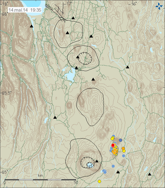
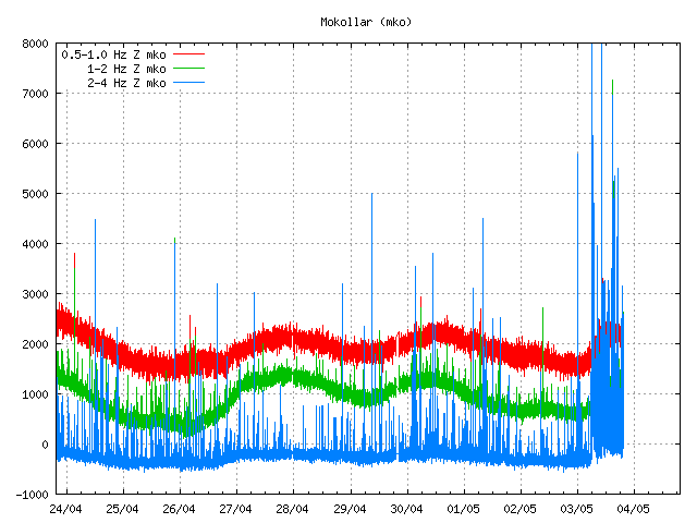
South Iceland Seismic Zone (SISZ)

Constant earthquake activity has been in SISZ over the week and it has been ongoing for the past weeks, none of the earthquakes have been large, with almost all of them being less then magnitude 1,0. Largest earthquake in this swarm had the magnitude of 2,5.

151011_1755
The earthquake activity on SISZ. Copyright of this image belongs to Iceland Met Office.
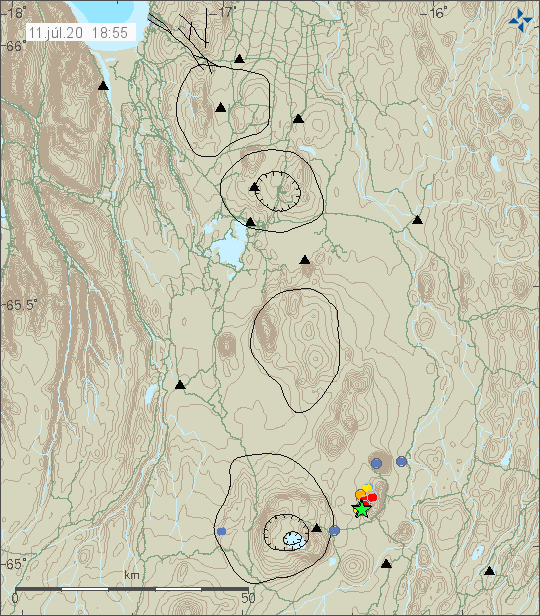
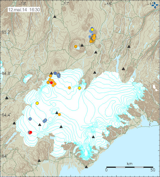
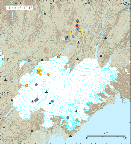
Bárðarbunga volcano

For most part earthquake activity in Bárðarbunga volcano was normal this week, with regular earthquake swarms taking place in the usual places. The most interesting earthquake this week took place under Trölladyngju, it was only magnitude 0,7, but it was on depth of 26,2 km.

151008_2140
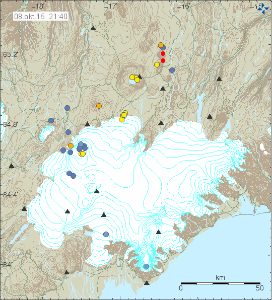
Earthquake activity in Bárðarbunga volcano. Copyright of this image belongs to Iceland Met Office.
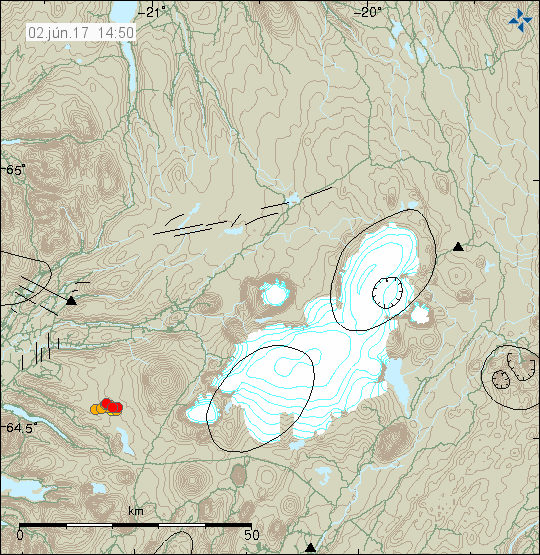
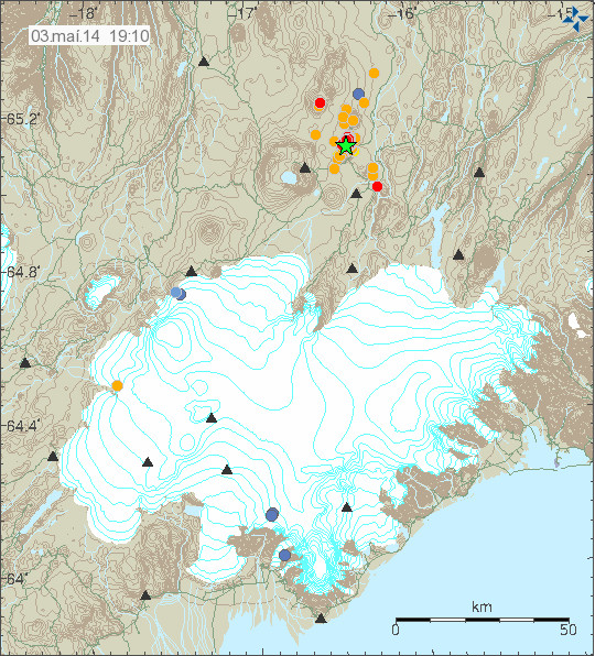
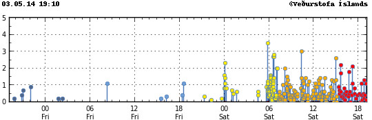
Herðubreið

Earthquake swarm has been taking place all week in Herðubreið. Earthquake swarms are common in this area and often have magnitude 3,0 earthquakes or larger. The earthquake swarm is ongoing when this is written.

151011_1815
Earthquake activity in Herðubreið/Herðubreiðarfjöll area (north of Askja volcano). Copyright of this image belongs to Iceland Met Office.
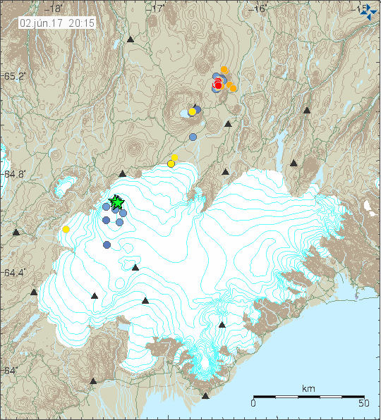
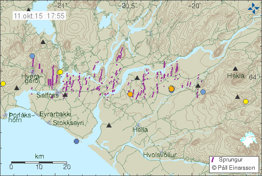
Reykjanes ridge

A magnitude 3,4 earthquake took place deep on the Reykjanes ridge this week. The earthquake was not felt and there might have been more than one earthquake. My geophone in Heklubyggð shows more than one earthquake one hour after the magnitude 3,4 earthquake happens.

151008_2040
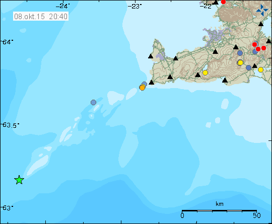
Earthquake activity on the Reykjanes ridge. Copyright of this image belongs to Iceland Met Office.

A magnitude 3,0 earthquake also took place around 200 km off the coast of Reykjanes peninsula (around 153 km south of Eldeyjarboða). That earthquake location was poor due to the distance from the SIL network.

Donations: Please remember to support my work here with donations or by using Amazon banners when you buy from Amazon. Thanks for the support.

New earthquake swarm in Herðubreið

Yesterday (14-May-2014) an earthquake swarm started in Herðubreið, after an earthquake swarm in Heruðbreiðartögl dropped in activity. Both earthquake swarms are currently active. The earthquake activity however drops between as the swarm activity picks up.

140514_1935_myvatn
The earthquake swarm in Herðubreið and Herðubreiðartögl. Copyright of this image belongs to Icelandic Meteorological Office.

Most of this earthquakes had the magnitude smaller then magnitude 2,0. There was one magnitude 2,4 earthquake in this swarm. Over 100 earthquakes where recorded during this swarm. It remains unclear what is creating this earthquake swarm. It might just be tectonic stresses in Herðubreið and nearby area, or this might be magma injection. So far there is nothing suggesting that an eruption is going to take place at this location.

Donations: Please remember to donate. I am now really, really broke and its just the middle of the month. Yes, I do hate being broke, but I don’t exactly have many options open to me at the moment when it comes to money. Thanks for the support.

Update on Herðubreiðartögl earthquake swarm 12-May-2014

This is the last update on the Herðubreiðartögl earthquake swarm for now.

During the weekend the earthquake activity in Herðubreiðartögl has been dropping in both magnitude and number of earthquakes taking place. No earthquake with magnitude 2,0 or stronger took place during the weekend.

140512_1630
The earthquake activity in Herðubreiðartögl. Also in this picture, earthquake activity in Bárðarbunga volcano. Copyright of this image belongs to Icelandic Meteorological Office.

Earthquake activity has not stopped at Herðubreiðartögl, it might increase again. For the moment it has slowed down and is now at the levels it is not necessary for me to post regular updates on what is taking place. If any major change happens in Herðubreiðartögl I am going to post information about it.

Donation notice: Please remember to support my work here with a donation. Thanks for the support.

Update on earthquake swarm in Herðubreiðartögl on 9-May-2014

This is a short update for the earthquake swarm in Herðubreiðartögl on the 9-May-2014.

For the past 24 hours there has been drop in activity and no earthquake has been over magnitude 2,0. Activity continues but a lot lower levels then before. It does not look like it is over at this point, but the end of this soon to be seven day earthquake swarm in this area.

140509_1905
The earthquake swarm in Herðubreiðartögl as it was today. It can be seen that earthquake activity was at lot lower levels today then yesterday (08-May-2014) or the days before that. Copyright of this image belongs to Icelandic Meteorological Office.

140509_1905_tracer
This can also be seen in the tracer on Icelandic Meteorological Office website. Copyright of this image belongs to Icelandic Meteorological Office.

ask.svd.09.05.2014.at.19.35.utc
This drop in activity can also be seen in drop in the harmonic tremor plots in Askja. Fewer earthquakes means less earthquake related noise on the harmonic tremor plot (2-4Hz blue line). Not all of the activity that appears here is from Herðubreiðartögl, some of it is from SISZ and Reykjanes ridge activity. Copyright of this image belongs to Icelandic Meteorological Office.

IASK.svd.09.05.2014.19.23.utc
The drumplot from Icelandic Meteorological Office also show this drop in activity. Some of the activity that appears is from Reykjanes Ridge. Copyright of this image belongs to Icelandic Meteorological Office.

None of this earthquake activity is strong enough to appear on my geophones. Since earthquakes at Herðubreiðartögl need to be at least magnitude 3,0 or larger to appear clearly on my geophones. My webicorders website can be found here, it shows all earthquakes that are taking place in Iceland and are large enough to appear on it. Its mostly earthquakes larger then magnitude 3,0 that are currently taking place (when this written).

Donation notice: Please remember to donate to support my work. Otherwise I am going to be broke this month and that is not a good thing. Thanks for the support.

Updated at 20:11 UTC.

Ongoing earthquake swarm north of Herðubreiðartögl

Today (03-May-2014) around midnight (00:02 UTC) a earthquake swarm started north of Herðubreiðartöglum (Global Volcanism Program link on Askja volcano can be found here), this area is an small mountain ridge that has built up with regular eruptions over some period of time. The largest earthquake in this swarm took place this morning at 05:49 UTC and had the magnitude of 3,5 with the depth of 7,6 km. After this earthquake took place the swarm increased with many minor earthquakes. So far over 265 earthquakes have been recorded today, this number gets obsoleted quickly since new earthquakes happens ever 1 to 3 minute when I am writing this text.

Tremor plot on nearby SIL stations show that a lot more earthquake activity is taking place than appears on IMO earthquake website. Reason for this is simple, the earthquakes cannot be located since they are only detected at one or two SIL stations, a minimal of three or four SIL station are required for location of each earthquake. The tremor plot in the area also show that no magma is erupting, but that does exclude the possibly that magma injection is responsible for this earthquake swarm. It has not reached the surface and currently there is no eruption taking place at this location. If an eruption takes place in this location, it is going to be Hawaiian eruption with large lava flows.

140503_1910
The earthquake swarm north of Herðubreiðartögl as they appear on Icelandic Meteorological Office maps. Copyright of this image belongs to Icelandic Meteorological Office.

140503_1910_tracer
The earthquake rate during this earthquake swarm. Copyright of this image belongs to Icelandic Meteorological Office.

ask.svd.03.05.2014.19.37.utc
The SIL station in Askja volcano. As can be seen the earthquake swarm is dense and highly active. Copyright of this image belongs to Icelandic Meteorological Office.

mko.svd.03.05.2014.19.38.utc
The SIL station south of Herðubreiðartögl, this SIL station is called Mókollar and the earthquake swarm appears clearly on it. Copyright of this image belongs to Icelandic Meteorological Office.

Earthquake swarms are common in this area and have been for a long time. Most of that earthquake activity has been contributed to normal tectonic activity in this region (plate tectonic movements). This area also has erupted in the past (last 12,000 years). I don’t think there have been any eruptions in this area in the past 1000 years, at least there are no such signs on the surface (crates, lavas). It is difficult to know what happens in this area for the next few hours to days, all that can be done is to continue monitor the activity that is now taking place. The largest earthquakes appears clearly on my Böðvarshólar geophone (link here), even if the distance is up to 200 km.

Donation note: Please remember to donate. Otherwise I am going to have a rather bad month of May in terms of being broke. Thanks for the support.