Earthquake swarm north of Kolbeinsey island

Around 11:00 UTC a earthquake swarm started just north of Kolbeinsey island. This earthquake swarm looks rather powerful. But due to distance from land only the largest earthquakes are appearing on the SIL network and on my geophone at Böðvarshólar. I am estimating the largest earthquakes having the magnitude of 4.0+. But that has not been confirmed yet. Last known eruption in Kolbeinsey island volcano took place in the year 1755. A dike intrusion or a volcano eruption took place north (100 km) of current location back in the year 1999. Last eruption before the eruption in the year 1755 took place around the year 1372.

130413_1745
The earthquake activity in Kolbeinsey island. It is marked by the green stars on this map. Copyright of this image belongs to Icelandic Meteorological Office.

bhrz.svd.13.04.2013.17.55.utc
The earthquake activity as it has been appearing on my geophone at Böðvarshólar. This image is under Creative Commons Licence. See CC licence page for more details.

No signs of eruption have appeared so far. If they do. They are going to appear on the SIL network. I am not sure if my geophone is going to pick them up due to the distance (around 300 km). There is a chance of more earthquake activity to take place in this area in the next few hours to days. I do not know if this activity is connected to what has been taking place in other parts of Tjörnes Fracture Zone. The smaller earthquakes that are taking place in Kolbeinsey island are not being detected by the SIL network or by my geophone.

It is possible to view the earthquake activity here, on my webicorder web page.

Blog post updated at 19:35 UTC on 13.04.2013.

Magnitude 4.4 earthquake north of Kolbeinsey Island

Today at 17:32 UTC there was a magnitude 4.4 earthquake north of Kolbeinsey Island. I do not know if this earthquake was tectonic or volcanic in nature. I do know that there where several aftershocks following this earthquake. Since I did register them on my geophone in north Iceland. The geophone web site can be viewed here. More information about the earthquake can be found here, on EMSC web page.

310421.regional.svd.29.03.2013.m4.4
Regional view of the area where the earthquake took place. Copyright of this image belongs to EMSC.

Icelandic Meteorological Office did also detected many of this earthquakes that took place there. But detection from this location is difficult due to distance from the SIL network.

130329_2050
The earthquake swarm location according to Icelandic Meteorological Office. Copyright of this image belongs to Icelandic Meteorological Office.

For now this is just a earthquake swarm and nothing else. Regardless of what happens later. Earthquake activity has been common in this area of the rift zone for several months now. I do not know why that is. The ocean depth in this area is around 3 to 4 km where it is the deepest. So if an eruption takes place there it is not going to be noticed due to the depth of the ocean.

Earthquake swarm north of Kolbeinsey Island

During the night (on 15.12.2012) there was a swarm of earthquakes far north of Kolbeinsey Island. The distance from Kolbeinsey Island is about 100 to 200 km. What exactly is taking place at this location is impossible to know for now. Since this is far from Iceland and the SIL network. Last eruption is believed to have taken place around this area back in the year 1999, or at least there was an large dike intrusion at that time. What did happen exactly is not known.


The earthquake activity north of Kolbeinsey Island at midnight (00:00 UTC) 15.12.2012. Copyright of this image belongs to Icelandic Meteorological Office.


Earthquake activity at 09:00 UTC this morning (15.12.2012). More earthquakes have taken place since midnight. Copyright of this image belongs to Icelandic Meteorological Office.

There is a chance of more earthquakes in this area. It can also be expected that not all earthquake activity in this area is being detected by the SIL network. Due to distance, weather and ocean activity.

Continued earthquake activity on Kolbeinsey Island ridge

In the past few days there has been considerable earthquake activity in Kolbeinsey Island ridge. Many of the earthquakes have been reaching the magnitude of at least 3.0. But some of it might be underestimation. As this earthquake activity is taking place far off Iceland coastline and far away from the SIL network. But that makes detection of earthquakes more difficult. Along with effects of weather and ocean waves that often prevent detection of smaller earthquakes in this area.


The location of the earthquake activity in Kolbeinsey Island ridge. Copyright of this image belongs to Icelandic Meteorological Office.

This is not the only activity in this area in the past few weeks. But the largest earthquake in this area was an magnitude 4.4 to 4.6 few weeks ago. So the activity in this area seems to be connected to something major. It is an question if this is due to volcano eruption currently taking place in this area now. But with depth of up to 4 km. It is impossible to know that for sure without actually going there on an ship. But given current weather. That is not going to happen any time soon. Maybe not for several years in fact.

Strong earthquake on Kolbeinsey Island ridge yesterday (06.09.2012)

Yesterday (06.09.2012) there was an earthquake about 200 km off Kolbeinsey Island. It was maybe on the Kolbeinsey Island or on SPAR fault zone in this area. I am not sure what is the actual case here. The earthquake had the magnitude of 4.4 and up to 4.7. Its magnitude has not yet been confirmed (EMSC web page can be found here). I do not know why that it. But this sometimes happen. This earthquake was not felt. But I did record it on my geophone network on two stations.


The location according to IMO. The second green star is an magnitude 3.6 earthquake in Jan Mayen. Copyright of this image belongs to Icelandic Meteorological Office.


The location according to EMSC. Copyright of this image belongs to EMSC.

This earthquake is one the strongest earthquakes that have been taking place in this area for the past few weeks. I do not know what is exactly happening in this area. This might be volcanic activity. But given depth of 2 km there. It is hard to know for sure. As any signs of eruption won’t appear on the surface of the ocean. Given that winter storm season has started in this area. Any sign of eruption are going to lost in the ocean waves. This area of the mid-Atlantic ridge might have more earthquakes in coming days to weeks.

Earthquake swarm on Kolbeinsey Ridge yesterday (30.08.2012)

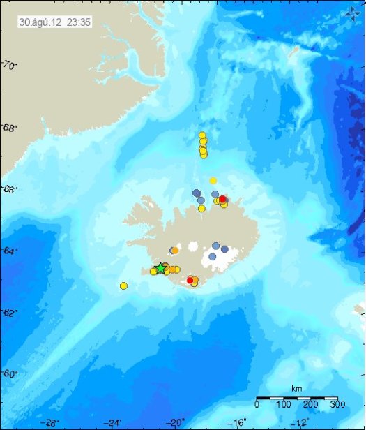
Yesterday (30.08.2012) there was an earthquake swarm on Kolbeinsey Ridge. But earthquakes have been taking place there for several weeks already. This earthquake activity seems to be growing in number of earthquakes swarms taking place. In the year 1999 there might have been an dike intrusion or submarine eruption south of Spar Fracture Zone (more details here). Last earthquake swarm that was noticed by the SIL network was exacly two months ago (30.06.2012). My coverage of that can be found here. But it was not in the same place. But that earthquake swarm was south of Kolbeinsey Island, not north of it as was the case yesterday.


The earthquake area in question are the yellow dots north of Iceland on this map from IMO. Copyright of this image belongs to Icelandic Meteorological Office.

What happens next in this area in terms of earthquake activity, or possible volcano activity is hard to impossible to know. As it is really hard to monitor volcanoes and rift zones that are under 2 km deep ocean and good distance from the coast line. However if there is any major earthquake activity in this area. It is going to appear clearly on my geophone network and IMO SIL network in Iceland.

Minor earthquake swarms in Iceland

It has been quiet in Iceland during the past few weeks. Besides activity in Katla volcano and Kolbeinsey ridge. Nothing of interest has been going on in Iceland. Here is however the overview of activity in Iceland during the past few hours.

Kolbeinsey Ridge

Some minor earthquake activity has been taking place in Kolbeinsey Ridge during the past few hours. This earthquake swarm is small in nature, with largest earthquakes reaching the magnitude 2.4. Otherwise it remains quiet in this area.


Earthquake activity in Kolbeinsey Ridge. Just north of Grímsey Island. Copyright of this image belongs to Iceland Meteorological Office.

Kolbeinsey ridge has seen some activity during past few weeks. But it might just be normal tectonic earthquakes taking place. So far nothing suggest any volcanism nature of this earthquake activity.

Krýsuvík volcano

During the past few hours. Krýsuvík volcano did see some earthquake activity. This activity is most likely to be tectonic in nature. As Reykjanes peninsula has frequent earthquake swarm that are tectonic in nature.


Earthquake swarm on Reykjanes. It is located within Krýsuvík volcano. This was small earthquake swarm. Copyright of this image belongs to Iceland Meteorological Office.

It remains rather quiet on Reykjanes besides this minor earthquake swarm today.

Katla volcano

After rather interesting activity during the past few weeks. It seems that Katla volcano is slowing down in earthquake activity. For now at least. But it is impossible to know for sure if current quiet sense is going to continue in Katla volcano.


Earthquake activity in Katla volcano during past few days. The activity is mostly concentrated into Katla volcano caldera. Copyright of this image belongs to Iceland Meteorological Office.

Besides this top of the activity. All is quiet in Iceland. Both in volcanoes and earthquakes. That might however change at any time without warning. It happens often in Iceland. I also want to remind people of my geophone web page. Where earthquakes can sometimes be seen soon after they have taken place.

Earthquake swarm in Katla volcano, Kolbeinsey ridge, Hveravellir geothermal area

It has been a bit busy day earthquake wise in Iceland. But there has been more activity today then in past few weeks in Iceland. But it has been really quiet for a long time now in Iceland. But let’s start with the largest earthquake of the day.

Kolbeinsey Ridge

Today at 11:11 UTC there was an earthquake with the magnitude of ML3.65. This earthquake was not felt since it was more then 100 km away from nearest human population in Iceland. The earthquake took place on Kolbeinsey Ridge. It last erupted in the year 1755. No known eruption is known in this area since then. My geophone network did record this earthquake properly. The signal was strongest at my Hvammstangi geophone station. But it was also recorded on my Heklubyggð geophone station. On other geophone stations. The signal was too weak to be properly detected by my geophone.


The ML3.65 magnitude earthquake as it was recorded on my Hvammstangi geophone. This image is released under Creative Commons licence. Please see the CC Licence page for more details.


The ML3.65 magnitude earthquake as it was recorded on my Heklubyggð geophone. It is filtered at 1Hz. This image is released under Creative Commons licence. Please see the CC Licence page for more details.


The location of the earthquake. Copyright of this picture belongs to Iceland Meteorological Office.

Hveravellir geothermal area

There is an earthquake swarm ongoing (or it might be over. I have no good way to know that currently) at Hveravellir geothermal area. I only know there is an earthquake swarm there because of the tremor recording on Hveravellir geothermal area. But only two earthquakes have been large enough to appear on earthquake map on IMO web page.


The two earthquakes that did appear on IMO earthquake map. Copyright of this picture belongs to Iceland Meteorological Office.


However, Hveravellir SIL station did show that more was going on then did appear on the earthquake map. Most of this earthquakes are too small to appear automatic on the earthquake list. Some might even be too weak to be properly located by the SIL network. Copyright of this picture belongs to Iceland Meteorological Office.


Some of this activity did also appear on Skrokkalda SIL station I think. Copyright of this picture belongs to Iceland Meteorological Office.

Katla volcano

Katla volcano did have an new earthquake swarm during the night. This earthquake swarm had around 30 or so earthquakes. Most of them where located almost in the central caldrea. This type of swarm activity has now been ongoing since end of April, when it started rather sharply with an earthquake swarm. Since then it has had many earthquake swarm. But the current rate of earthquake swarm is around 1 to 3 earthquake swarm pr. Week. Normally they are in an new area inside the Katla volcano caldera.

My geophone station at Skeiðflöt records most of the earthquakes if the background noise is not too high during that time.


The earthquake activity in Katla volcano last night. Copyright of this picture belongs to Iceland Meteorological Office.

So far. This is just normal earthquake activity. It does not signal any chance of eruption activity so far. But this earthquake pattern is interesting. What it means is a different matter. So far, nobody knows for sure at this point in time. This activity seems to change hydrothermal activity inside Katla volcano caldera. This has also created minor glacier floods from Katla volcano caldera. But the flood have been seen on instruments that record water conditions in Múlakvíls glacier river. Glacier floods are marked by higher conductivity of the water, darker color and stronger sulfur smell (rotten egg smell). What happens next in Katla volcano is anyone guess. As Katla volcano has proven to be unpredictable volcano.

Earthquakes in Katla volcano. Earthquake swarm continues close to Herðubreið. Other earthquake activity

This morning there was a short earthquake swarm in Katla volcano caldera. This earthquake looks like a minor dike intrusion did take place this morning. Current series of events did start on 28. April 2012. With a small earthquake event and a small glacier flood that did follow it. Along with harmonic tremors coming from the glacier flood and possibly Katla volcano caldera (hydro-thermal activity boiling or something of that nature). I do not yet know if there was any glacier flood following the event this morning. But so far there is nothing that suggests a small glacier flood did take place following the earthquake swarm this morning.

The earthquake swarm this morning took place on an location that did erupt on 8 and 9th of July 2011. So it is clear the area that erupted last year is picking up activity again. But there was an drop in activity from end of November 2011 until end of April 2012.


Earthquake activity in Katla volcano this morning. Copyright of this picture belongs to Icelandic Meteorological Office.

This earthquake activity did appear well on my geophone at Skeiðflöt farm.


Earthquake activity in Katla volcano caldera this morning on my Skeiðflöt geophone. There is a lot of noise on this geophone. But earthquake activity can still be seen on this. The earthquakes are marked by red (some noise is also marked by red). This picture is released under Creative Commons Licence. See CC Licence page for more details.

It is clear that Katla volcano seems to be warming up to an eruption. But it is impossible to know when such eruption might happen, or how big it is going to be.

Herðubreið

Earthquake activity continues south-west of Herðubreið. But almost all of the earthquakes have been less then ML2.0 in magnitude. Earthquake activity has been slowing down all day. At the moment, it appears this earthquake swarm is close to being over.


The earthquake activity close to Herðubreið mountain. Copyright of this picture belongs to Icelandic Meteorological Office.

This area is well known for for earthquake activity. So this is not something that is new in this area.

Reykjanes Ridge

According to EMSC and USGS there have been several earthquakes with the magnitude of Mb4.5 to Mb4.8 on the Reykjanes Ridge. Earthquake activity is common on the Reykjanes Ridge. But because of the location and depth (around 2km) it is impossible to know if there any volcano eruption taking place at this location. It might well be, or not.

Kolbeinsey Island

Over the past weeks there has been some earthquake activity close to or in Kolbeinsey Island. The largest earthquakes have had the magnitude around ML3.0, with some underestimates due to distance from the SIL network. At this moment it is impossible to know if this earthquake activity is related to possible eruption activity. But it believed that an eruption (or dike intrusion) took place on Kolbeinsey Ridge in the year 1999. It started off with a large earthquake swarm.

Quiet scene goes into third week

The quiet scene that has been taking place in Iceland over the last two weeks is still ongoing and is now entering it’s third week. Over the last two week there have been less then 300 earthquakes during a single week. In Iceland that is quiet.

All volcanoes in Iceland have mostly been quiet. But there was a unconfirmed earthquake swarm in Grímsfjall volcano. But due to extremely bad weather it was not observed properly by the SIL network. North of Iceland there also has been a unconfirmed earthquake swarm. This earthquake swarm is somewhere north of Kolbeinsey volcano. But due to distance and bad weather it is unknown how big it was. But the largest earthquakes that have appeared on the SIL network did manage to go up to ML3.0 in size. But that is mostly a underestimate on the size of this event. But underestimate on a earthquake size happens when it is far from SIL network and not properly recorded due that.